
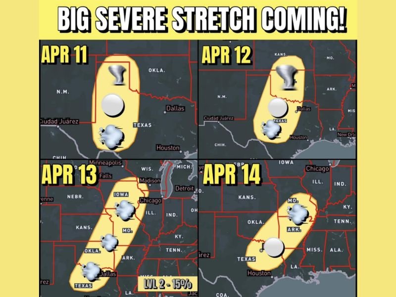
This Weekend Into Early Next Week: Texas, Oklahoma, Iowa, Illinois, Arkansas, Mississippi, and Louisiana Face 4-Day Severe Storm Stretch With Tornado, Hail, and Heavy Rain Risks
UNITED STATES — A prolonged and active severe weather pattern is expected to unfold over four consecutive days, beginning this weekend across Texas and Oklahoma before shifting east into Iowa and Illinois and then back south toward Arkansas, Mississippi, and Louisiana, bringing repeated risks of storms capable of producing hail, damaging winds, tornadoes, and heavy rainfall.
Saturday Starts the Severe Pattern Across Texas and Oklahoma
The first round of storms is expected Saturday across parts of west Texas and Oklahoma. This initial setup marks the beginning of a multi-day stretch, with storms capable of becoming strong and producing severe weather. All hazards could begin to appear early in this cycle, including hail and strong wind gusts.
Sunday Expands the Risk Across More of Texas and Oklahoma
By Sunday, the severe threat is expected to expand across a broader portion of Texas and Oklahoma. Storm coverage is likely to increase, with conditions becoming more favorable for organized severe weather.
This includes continued risks of large hail, damaging winds, and isolated tornadoes, along with heavy rainfall in stronger storm clusters.
Monday Pushes Severe Threat Into Iowa and Illinois
As the system moves east, Monday’s focus shifts into parts of Iowa and Illinois, bringing severe storm potential closer to the Midwest.
This phase of the pattern could impact major areas including regions near Chicago, with storms capable of producing similar hazards seen earlier in the weekend.
Tuesday Shifts Activity Back South Toward the Gulf States
By Tuesday, a cold front is expected to push the main storm focus back toward the south, including Arkansas, Mississippi, and Louisiana.
This shift keeps the active pattern going, with continued storm chances and potential for severe weather in these regions.
Repeated Storm Days Increase Overall Impact Risk
With four consecutive days of severe weather potential, the repeated rounds of storms raise concerns for cumulative impacts, including localized flooding and repeated severe weather events in some areas.
Forecast trends suggest all modes of severe weather remain possible each day, making this an extended period to monitor closely. Stay with NapervilleLocal.com for the latest weather updates and local forecast coverage.

I’ve lived in Naperville long enough to see how quickly our community changes — from new developments downtown to sudden shifts in our Midwest weather. Reporting on Naperville news and daily forecasts gives me the chance to keep neighbors informed about what really matters. My goal is simple: deliver clear, timely updates so you always know what’s happening in our city and what to expect from the skies above.