
Monday Into Monday Night: Iowa, Illinois, Missouri, Nebraska, Kansas, Wisconsin, and Minnesota Face Significant Severe Storm Threat With Tornadoes, Large Hail, and Damaging Winds
UNITED STATES — A significant severe weather event is expected to develop Monday into Monday night, impacting a large portion of the Central Plains and Mid-Mississippi Valley, with an increasing risk for tornadoes, large hail, damaging winds, and heavy rainfall.
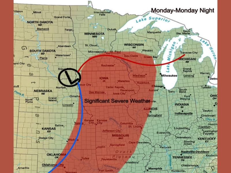
Large Severe Weather Zone Expands From Plains Into Midwest
Forecast data shows a broad area of severe weather stretching from parts of Nebraska and Kansas through Iowa, Missouri, and into Illinois, Wisconsin, and Minnesota.
This wide coverage suggests a more organized and impactful system, with multiple states facing heightened storm risks throughout the day and evening.
Storms Likely to Develop Along Frontal Boundary
Storm development is expected along a boundary that may act as either a cold front or dryline, depending on how the system evolves.
This boundary will serve as the focus for thunderstorm initiation during the afternoon, with storms rapidly intensifying as they move east and northeast into the evening hours.
All Severe Weather Hazards Possible
Atmospheric conditions appear favorable for an all-hazards severe weather event, meaning storms could produce:
- Tornadoes, including the potential for stronger, more organized storms
- Large hail, especially with early discrete supercells
- Damaging winds, as storms grow into clusters or lines
- Heavy rainfall, which could lead to localized flooding
Moisture and Wind Shear Support Strong Storm Development
Strong southwest flow combined with increasing low-level moisture will create an environment supportive of severe thunderstorms.
Wind shear across the region will further enhance storm organization, increasing the likelihood of sustained severe storms rather than brief, isolated cells.
Timing Focused on Afternoon and Evening Hours
The primary window for severe weather is expected during the afternoon and evening hours on Monday, with storms continuing into the night as they track across the Midwest.
Residents in the affected areas should remain alert as conditions could change quickly once storms begin to develop. Stay with NapervilleLocal.com for the latest weather updates and local forecast coverage.

I’ve lived in Naperville long enough to see how quickly our community changes — from new developments downtown to sudden shifts in our Midwest weather. Reporting on Naperville news and daily forecasts gives me the chance to keep neighbors informed about what really matters. My goal is simple: deliver clear, timely updates so you always know what’s happening in our city and what to expect from the skies above.