
Today Through Early Next Week: Oklahoma Faces Warm 80s, Increasing Storm Chances, and Peak Severe Threat Monday and Tuesday With Hail and Strong Winds
OKLAHOMA — A shift toward a more active weather pattern is underway, with warm and windy conditions today followed by increasing chances for showers and thunderstorms into the weekend, and a higher risk for severe weather early next week, especially Monday and Tuesday.
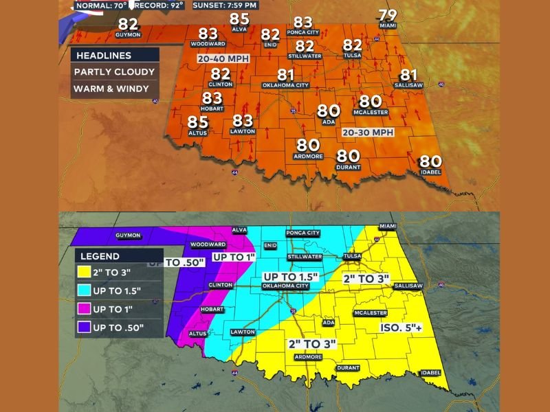
Warm and Windy Conditions Dominate Today
Today will feel more like early summer across Oklahoma, with temperatures climbing into the low to mid 80s statewide.
Winds will be noticeable throughout the day, with sustained speeds around 20 to 30 mph, making conditions feel even more dynamic despite limited rainfall early on.
Isolated Storms Possible This Afternoon and Evening
Storms are expected to develop along a boundary in the northwestern part of the state later today. While coverage will remain limited, a few storms could become strong to marginally severe, with threats including gusty winds and small hail.
Rain and Storm Chances Increase Into the Weekend
By Friday and into the weekend, storm chances begin to increase as moisture continues to build across the region. Rain coverage will remain somewhat scattered, but more areas could begin to see measurable rainfall, especially across central and eastern Oklahoma.
Monday and Tuesday Bring Highest Severe Weather Risk
The most significant concern arrives early next week, with Monday and Tuesday showing the highest potential for severe storms.
Forecast trends suggest storms during this period could produce large hail, damaging winds, and possibly tornadoes, especially as conditions become more favorable for organized storm systems.
Rainfall Totals Could Reach 2 to 3 Inches in Some Areas
Rainfall projections indicate that parts of Oklahoma, particularly southern and eastern regions, could receive 2 to 3 inches of rain over the coming days.
Other areas, including central parts of the state, may see totals closer to 1 to 1.5 inches, with lighter amounts farther west.
Active Pattern Continues Into Early Next Week
The overall pattern remains active through early next week, with multiple opportunities for storms and beneficial rainfall.
While not every location will see rain each day, the trend points toward a wetter period with increasing storm chances across the state. Stay with NapervilleLocal.com for the latest weather updates and local forecast coverage.

I’ve lived in Naperville long enough to see how quickly our community changes — from new developments downtown to sudden shifts in our Midwest weather. Reporting on Naperville news and daily forecasts gives me the chance to keep neighbors informed about what really matters. My goal is simple: deliver clear, timely updates so you always know what’s happening in our city and what to expect from the skies above.