
Next 10–12 Days: Alabama, Georgia, Mississippi, South Carolina Face Near-Zero Rainfall While Missouri, Kansas, Oklahoma See 2–3+ Inches
ALABAMA — A sharp weather contrast is setting up across the country over the next 10 to 12 days, with much of the Southeast—including Alabama, Georgia, Mississippi, and South Carolina—expected to see little to no rainfall, while parts of the Plains and Midwest receive significantly higher totals. Forecast data shows a persistent dry pattern in the South driven by a strong ridge, raising growing concerns about drought conditions and fire risk.
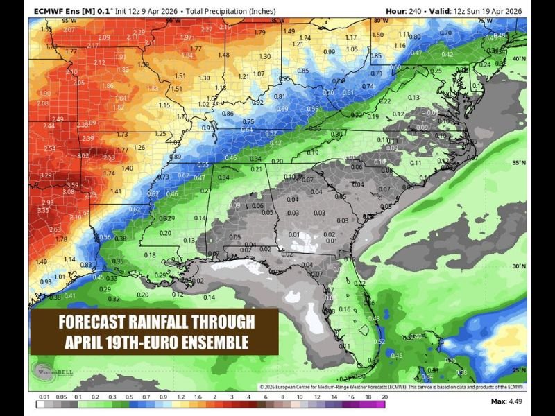
Southeast Locked Into Extended Dry Pattern
The forecast clearly shows Alabama, Georgia, Mississippi, and South Carolina sitting in the lowest rainfall zone, with many areas expected to receive almost no measurable rain through the next 10–12 days.
This is unusual for April, typically one of the wetter months. Instead, a dominant ridge positioned to the south is blocking storm systems from moving into the region. As a result, day after day of dry weather is expected, with no significant rain chances in sight.
Warm Temperatures Building Into the 80s
Along with the dry stretch, temperatures are expected to steadily rise. Highs will climb into the upper 70s to mid-80s, bringing a warm and sunny pattern across the Southeast.
Morning conditions may start cooler, but rapid daytime warming will take over with plenty of sunshine and light winds. Overall, conditions will feel pleasant but increasingly dry.
Weekend Stays Dry and Warmer
The upcoming weekend continues the same trend. Expect dry, sunny skies with highs in the mid-80s across much of the region.
With no rain in the forecast, outdoor conditions will be ideal, but the lack of moisture will continue to dry out soil and vegetation. Evenings will remain comfortable due to low humidity levels.
Next Week Brings More of the Same
Looking ahead, next week shows no major change in the pattern. The ridge remains in place, keeping storm systems well to the north and west.
While parts of the central U.S.—including Missouri, Kansas, and Oklahoma—are expected to see heavier rainfall totals exceeding 2 to 3 inches, that activity will not reach the Southeast.
Only a very small chance of isolated showers appears late in the period, but widespread rain remains unlikely.
Drought Concerns and Fire Risk Increasing
With such an extended dry stretch, drought conditions are expected to worsen across the Southeast. The lack of rainfall combined with warmer temperatures will increase stress on vegetation and soil moisture.
Fire danger may also begin to rise, especially in areas that continue to dry out over the coming days. Residents are encouraged to remain mindful of outdoor burning and take precautions. Stay with NapervilleLocal.com for the latest weather updates and local forecast coverage.

I’ve lived in Naperville long enough to see how quickly our community changes — from new developments downtown to sudden shifts in our Midwest weather. Reporting on Naperville news and daily forecasts gives me the chance to keep neighbors informed about what really matters. My goal is simple: deliver clear, timely updates so you always know what’s happening in our city and what to expect from the skies above.