
Today and Saturday: Colorado, Southeast Wyoming and Southwest Kansas See Afternoon Storms After 1 PM With Gusty Winds, Hail and Snow Above 11,000 Feet
DENVER, COLORADO — Scattered showers and thunderstorms are expected to develop across Colorado and surrounding areas beginning this afternoon, with activity starting along the Continental Divide after 1 PM and expanding eastward into the Front Range, I-25 corridor, and eastern plains through the late afternoon and evening.
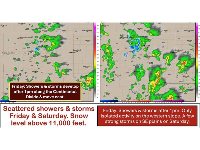
Storms Develop After 1 PM Along the Continental Divide
Today’s activity will begin after 1 PM, first forming over the higher terrain along the Continental Divide before gradually moving east.
Storms are expected to reach the Front Range and I-25 corridor around 3 PM, then continue pushing onto the eastern plains shortly after. Coverage will remain scattered, with limited moisture in place.
Gusty Winds and Lightning Main Threats Today
Most storms today will produce gusty winds and lightning, with only brief downpours in some areas.
A few stronger storms are possible later this evening, especially across southeast Colorado into southwest Kansas, where conditions could support more organized activity.
Isolated Activity in Western Colorado and Wyoming
The western slope will see very limited activity, with only a few isolated showers expected over higher terrain.
Similar conditions extend into southeast Wyoming and the western Nebraska Panhandle, where only spotty showers or a brief thunderstorm may develop.
Snow Possible Above 11,000 Feet
At higher elevations, colder air will allow for snow showers above 11,000 feet, especially in the mountains.
This will remain confined to the highest terrain and will not impact lower elevations.
Saturday Brings More Widespread Storm Activity
Storm coverage increases on Saturday as multiple rounds of showers and thunderstorms move through the region.
Activity will become more widespread after 2 PM, including the western slope, before gradually tapering off from west to east during the evening hours.
Stronger Storms Possible in Southeast Colorado and Southwest Kansas
A few storms on Saturday could become stronger, particularly across southeast Colorado and southwest Kansas, where large hail and damaging winds are the primary concerns.
Storms may continue into the night across the plains, while ending earlier in western areas. Stay with NapervilleLocal.com for the latest weather updates and local forecast coverage.

Naperville is a community with stories that deserve to be told — both the serious ones about safety and justice, and the lighter ones that capture our culture and daily life. I focus on covering crime reports and court updates while also highlighting the traditions, events, and social trends that shape who we are. Through my reporting, I want to give readers a fuller picture of Naperville — the challenges we face and the character that keeps our city strong.