
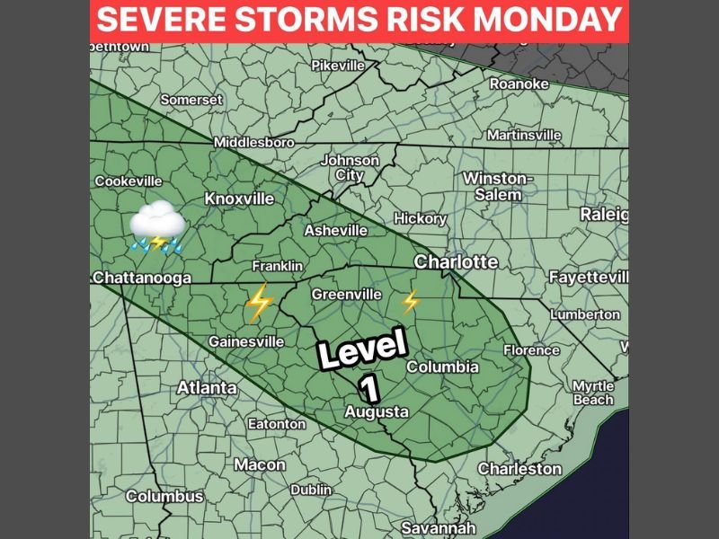
Level 1 Severe Storm Risk With Gusty Winds, Hail, and Lightning Targeting the Carolinas Including Charlotte, Greenville, and Columbia Monday June 1
CAROLINAS AND SOUTHEAST — A Level 1 severe weather risk is building across a broad corridor stretching from the Tennessee border southward through the Carolinas and into Georgia on Monday, June 1, 2026, as a reinforcing shot of cooler air from the northwest sparks stronger storms during the afternoon and evening. Strong gusty winds, some hail, and frequent lightning are the primary hazards, with this setup driven by upper-level dynamics meaning it can pack a punch despite the cooler temperature environment arriving with the system.
Upper-Level Dynamics Driving Monday’s Storm Risk Across the Carolinas and Southeast
Monday’s setup is notably different from typical summer storm patterns because the energy arrives from the northwest driven by upper-level atmospheric dynamics rather than surface heating. These northwest-driven systems can surprise residents with their intensity despite cooler ambient temperatures, making awareness just as critical as during warmer season setups.
The Level 1 risk zone covers a wide corridor from Johnson City and Knoxville southeastward through Asheville, Greenville, Charlotte, Columbia, Augusta, and toward Charleston and Savannah.
Gusty Winds, Hail, and Frequent Lightning the Three Primary Hazards Monday
Strong and gusty winds are the headline threat with Monday’s storm system, alongside hail potential and frequent lightning across the entire risk zone. Any stronger storm developing during the afternoon and evening window will be capable of producing brief but impactful wind damage across the Charlotte, Greenville, Columbia, and Augusta corridors.
Raleigh, Fayetteville, Hickory, Winston-Salem, and Myrtle Beach all fall within the outer edges of the Level 1 risk zone and should monitor conditions through the day.
Cool Nights With 40s in Mountains and 50s Across the Upstate Following Monday’s Event
The good news following Monday’s storm risk is a welcome shot of cooler air arriving behind the system, with overnight lows dipping into the 40s across the mountains and 50s across much of the Upstate through a couple of nights. After weeks of heat and humidity this cooling trend will be a meaningful and welcome change for residents across the entire Carolinas region. Stay with NapervilleLocal.com for the latest weather updates and local forecast coverage.

I’ve lived in Naperville long enough to see how quickly our community changes — from new developments downtown to sudden shifts in our Midwest weather. Reporting on Naperville news and daily forecasts gives me the chance to keep neighbors informed about what really matters. My goal is simple: deliver clear, timely updates so you always know what’s happening in our city and what to expect from the skies above.