
Powerful Storm System Bringing Frozen Precipitation, Snow on Mount Washington, and a Boat Aground in Hampton as Cold Air Surges Into New Hampshire and Massachusetts
NEW ENGLAND — A powerful and still-cranking storm system is battering New England Saturday morning, hauling in a boatload of cold air that is dropping temperatures steadily across the region while frozen precipitation continues to show up on radar across portions of New Hampshire, Vermont, and Massachusetts.
The storm has already produced dramatic impacts including a boat breaking free in Hampton, New Hampshire and running aground on the rocks in the Hampton River, while snow is accumulating at the Mount Washington Observatory and Cog Railway as the cold air pushes aggressively into the higher elevations.
Frozen Precipitation Hanging on Radar as Temperatures Continue Dropping All Morning
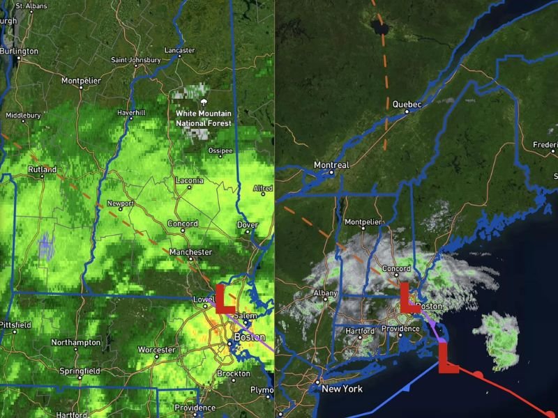
Radar at 9:45AM shows widespread green coverage blanketing New Hampshire and Vermont from Concord and Manchester through the White Mountain National Forest zone, with frozen precipitation signatures visible across the higher terrain zones. Temperatures have been dropping consistently throughout the morning as the storm system continues pulling cold air into the region from the north.
The low pressure center is positioned near the Boston and Salem corridor, keeping the most active precipitation focused across southern New Hampshire and northeastern Massachusetts through the morning. The system shows no signs of weakening quickly as it continues to haul cold air into the region.
Boat Breaks Free and Runs Aground on Rocks in Hampton New Hampshire During Storm
A boat broke free from its moorings during the storm and is now aground on the rocks in the Hampton River in Hampton, New Hampshire, providing a dramatic and visual reminder of the storm’s intensity along the New England coastline. Photos from the scene show the vessel lodged against the rocky shoreline with rough surf conditions visible in the surrounding water.
Coastal impacts from this storm system are significant, with dangerous marine conditions and rough seas creating hazardous situations along the New Hampshire and Massachusetts coastlines through the day.
Snow Accumulating at Mount Washington Observatory With Dramatic Images From the Summit
Striking photos from the Mount Washington Observatory and Cog Railway show snow accumulating across the summit zone, with the iconic observatory facilities blanketed in white despite the late May calendar date. The images from the Cog Railway base and summit areas capture the dramatic contrast of late season mountain snow driven by the powerful cold air surge accompanying this storm system. Stay with NapervilleLocal.com for the latest weather updates and local forecast coverage.

I’ve lived in Naperville long enough to see how quickly our community changes — from new developments downtown to sudden shifts in our Midwest weather. Reporting on Naperville news and daily forecasts gives me the chance to keep neighbors informed about what really matters. My goal is simple: deliver clear, timely updates so you always know what’s happening in our city and what to expect from the skies above.