
Saturday: Slight Risk of Severe Thunderstorms Targets West Texas This Afternoon With Large Hail, Damaging Winds, and an Isolated Tornado Possible Along the I-20 Corridor
SAN ANGELO, Texas — Severe weather is set to develop across the southern High Plains this afternoon and evening, with west Texas bearing the brunt of the most organized and dangerous activity. A Slight Risk of severe weather has been issued for the region, driven by a strengthening upper-level jet stream and rapidly increasing moisture working together to fire scattered thunderstorms that could quickly turn severe. Residents across the affected zone should remain weather aware through tonight.
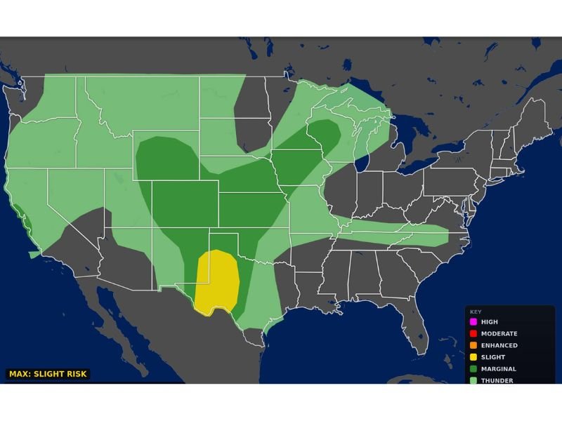
Slight Risk Centered Over West Texas
The categorical severe weather outlook issued by Max Velocity Weather on Saturday morning places a Slight Risk — shown in yellow on the outlook map — directly over west Texas, making it the highest-risk zone in the country for severe weather today. Surrounding areas across a broader portion of the southern plains fall under a Marginal Risk designation, while a general thunder threat extends across much of the central and eastern United States.
The Slight Risk zone is the second tier on the severe weather scale, indicating a real and meaningful threat of scattered severe storms capable of producing significant hazards.
Large Hail and Damaging Winds Are the Primary Threats
The two headline hazards with today’s storm setup are large hail and damaging winds. A strengthening upper-level jet stream combined with increasing low-level moisture will provide the ingredients needed for thunderstorms to rapidly intensify once they fire during the afternoon hours.
Storm mode is expected to initially favor discrete supercell thunderstorms — the type most capable of producing large hail and strong surface winds — before storms potentially evolve into clusters or short line segments later in the evening as the overall storm system organizes further.
Brief Tornado Cannot Be Ruled Out
While hail and wind are the primary concerns, forecasters are not ruling out the possibility of a brief tornado, particularly during the early stages of storm development this afternoon. Isolated supercell thunderstorms that can hold together before merging into clusters carry the greatest tornado potential.
Residents in and around the highest-risk communities should have a way to receive immediate weather alerts and know their plan of action if a tornado warning is issued for their area this afternoon or evening.
Midland, Odessa, Abilene, and San Angelo at Greatest Risk
The communities facing the highest level of concern today are those located along and south of the Interstate 20 corridor in west Texas. Midland, Odessa, San Angelo, and Abilene are specifically identified as being at greatest risk, along with surrounding communities in that region.
Anyone in these areas should monitor the forecast closely throughout the afternoon and avoid being caught outdoors or in vulnerable structures if storms develop nearby. Severe thunderstorms in this part of Texas can move quickly and intensify with very little warning time.
Storms Expected to Persist Into the Evening Before Weakening Overnight
Storm activity is forecast to continue through the evening hours before gradually weakening as the night progresses. While the most intense period is expected during the afternoon and early evening, residents should remain weather aware all the way through tonight until conditions fully settle down.
The outlook was last updated at 4:52 AM ET on April 11, 2026, and additional updates from forecasters are expected as the storm system develops throughout the day. Stay with NapervilleLocal.com for the latest weather updates and local forecast coverage.

I’ve lived in Naperville long enough to see how quickly our community changes — from new developments downtown to sudden shifts in our Midwest weather. Reporting on Naperville news and daily forecasts gives me the chance to keep neighbors informed about what really matters. My goal is simple: deliver clear, timely updates so you always know what’s happening in our city and what to expect from the skies above.