
Sunday: Severe Storms Threaten Texas, Oklahoma, and Kansas All Day With 2+ Inch Hail Near DFW and an Isolated Supercell Tornado Risk Up to EF-2 Strength
DALLAS, Texas — A complicated and conditional severe weather setup is unfolding across a large portion of the south-central United States today, with Texas bearing the heaviest brunt of the threat. Ongoing storm activity across Texas will influence and reshape where new severe storms redevelop later this afternoon, with large hail being the headline hazard — particularly around the Dallas-Fort Worth area where hail exceeding 2 inches in diameter is possible.
A dryline stretching from southern Kansas through Oklahoma and back into Texas adds further uncertainty to an already complex forecast.
Large Hail the Primary Threat — Over 2 Inches Possible Near DFW
The most significant and confident hazard in today’s setup is large hail. Ongoing storm activity across Texas through the morning and early afternoon hours will set the stage for new storm redevelopment later today, and when those storms fire, hail will be the dominant threat.
Around the Dallas-Fort Worth metroplex specifically, hail of more than 2 inches in diameter is possible — large enough to cause significant damage to vehicles, rooftops, and anything left exposed outdoors. Residents across the DFW area should be prepared to move vehicles into covered parking and stay indoors if severe thunderstorm warnings are issued this afternoon.
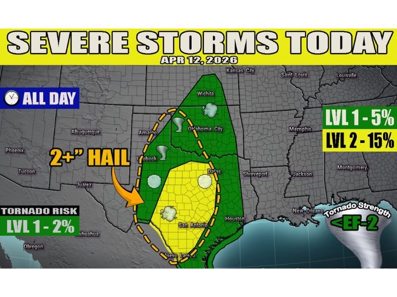
Level 2 Risk at 15% Covers Central Texas Through Southern Oklahoma
The outlook map shows a Level 2 severe weather risk — carrying a 15% probability — covering a broad yellow zone stretching across central Texas including the Dallas, San Antonio, and Lubbock corridors and extending northward through western Oklahoma toward Amarillo and Oklahoma City. This is the primary concern zone for the most organized and impactful storm activity today.
A surrounding Level 1 risk at 5% extends the threat further, encompassing a wider green zone that reaches northward through Wichita and Kansas City, covering communities across southern Kansas, central Oklahoma, and deeper into east Texas toward Houston and Shreveport.
Dryline Sparks Uncertainty From Kansas Through Oklahoma Into Texas
Further west, a dryline extending from southern Kansas southward through Oklahoma and back into Texas introduces a significant layer of forecast uncertainty. Most high-resolution weather models are indicating little to no storm development along this boundary, but strong atmospheric instability and surface convergence could be enough to ignite one or two isolated supercell thunderstorms.
If those supercells manage to develop along the dryline, the surrounding environment would be supportive of all severe weather modes — meaning hail, damaging winds, and even tornadoes could not be ruled out from any storm that does form in that zone.
Tornado Risk Present — Up to EF-2 Strength Possible
A tornado risk is included in today’s outlook at Level 1 carrying a 2% probability. While the overall tornado threat is relatively low, forecasters note that any tornado that does develop today could reach up to EF-2 intensity — strong enough to cause considerable structural damage, snap or uproot trees, and pose a serious danger to life and property.
The tornado risk is most closely tied to the dryline supercell scenario across western Texas, Oklahoma, and the southern Kansas region, where isolated storm cells would have the best opportunity to develop and maintain rotation before merging into larger clusters.
Severe Weather Threat Persists All Day
Unlike some severe weather setups that are confined to a narrow afternoon or evening window, today’s threat is active all day long across the affected region. Residents across Texas, Oklahoma, and southern Kansas should remain weather aware from morning through the late evening hours and keep a close eye on updated forecasts and any warnings issued for their specific area throughout the day.
Stay with NapervilleLocal.com for the latest weather updates and local forecast coverage.

I’ve lived in Naperville long enough to see how quickly our community changes — from new developments downtown to sudden shifts in our Midwest weather. Reporting on Naperville news and daily forecasts gives me the chance to keep neighbors informed about what really matters. My goal is simple: deliver clear, timely updates so you always know what’s happening in our city and what to expect from the skies above.