
Near-Record Heat Bakes Alabama Through the Week Before a Much-Needed Cold Front Brings a Shot of Weekend Rain and Cooler Air Back to the State
BIRMINGHAM, Ala. — There is some encouraging news on the horizon for drought-weary Alabama residents — both the GFS and European weather models are now in agreement that a cold front will deliver at least a chance of rain this weekend, offering a brief but welcome interruption to what has been a relentlessly hot and dry stretch across the state.
Until that front arrives, however, Alabama is staring down near-record afternoon heat pushing into the 80s and potentially touching 90°F by the end of the week, breezy conditions, and bone-dry skies.
Near-Record Heat Dominates Through the Week
Before any relief arrives, Alabama must first get through a prolonged stretch of exceptional warmth. Highs in the 80s are locked in through the week with partly to mostly sunny skies and breezy conditions making each afternoon feel increasingly summer-like. By the end of the week, temperatures could push toward or touch 90°F — territory that would approach or break records for this point in April.
Cool mornings will offer brief daily relief with overnight lows dropping into more comfortable territory, but afternoons will be relentlessly warm and dry with no meaningful cloud cover or rainfall to break the pattern before the weekend.
GFS and Euro Models Agree — Rain Possible This Weekend
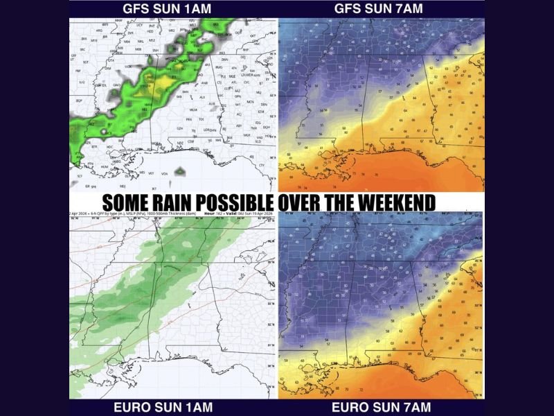
The headline good news is that both major global weather models — the American GFS and the European ECMWF — are now aligned on a cold front bringing at least a chance of rain to Alabama this weekend. Model agreement at this range adds meaningful confidence to the forecast and gives residents reason for cautious optimism after an extended dry stretch.
GFS model data shows rain developing overnight Sunday around 1 AM before spreading further by 7 AM Sunday morning. The European model paints a similar picture, with moisture working into the region during the same overnight-to-morning window and cooler air following closely behind.
Around a Quarter Inch Expected — More Possible to the West
While any rain at this point is welcome news, forecasters are managing expectations carefully. Ensemble guidance — which combines multiple model runs to assess probability — does not currently support a heavy or widespread soaking rainfall event. The most likely outcome is around a quarter inch of precipitation for most of Alabama, with western portions of the state standing the best chance of seeing slightly higher totals.
It is not the deep drought-busting rain the state truly needs, but it is something — and forecasters are taking that perspective seriously given how dry conditions have become.
Cooler Air Follows the Front — Lows Drop Back to the 40s
Following the frontal passage, a noticeable and welcome drop in temperatures will accompany the rain. Overnight lows will fall back into the 40s behind the front — a significant cooldown from the warm nights that have preceded it. No frost or freeze is expected with this particular system, but the temperature contrast will be immediately noticeable and refreshing after the oppressive heat of the week.
Another potential weather system is also being watched for around April 23rd and 24th, though how much rain that could bring remains uncertain at this stage. Stay with NapervilleLocal.com for the latest weather updates and local forecast coverage.

I’ve lived in Naperville long enough to see how quickly our community changes — from new developments downtown to sudden shifts in our Midwest weather. Reporting on Naperville news and daily forecasts gives me the chance to keep neighbors informed about what really matters. My goal is simple: deliver clear, timely updates so you always know what’s happening in our city and what to expect from the skies above.