
Category 5 Super Typhoon Sinlaku Barreling Toward Saipan and Tinian With 175 MPH Winds as Guam Braces for Tropical Storm Conditions Through Wednesday
SAIPAN, Mariana Islands — One of the most violent tropical systems on the planet is bearing down on the Mariana Islands right now, and preparations must be rushed to completion without a single moment of delay. Super Typhoon Sinlaku has reached Category 5 intensity with maximum sustained winds of 175 mph, putting it on a direct and catastrophic collision course with the islands of Saipan and Tinian. Tuesday preparations must be completed immediately — there is no time left to wait.
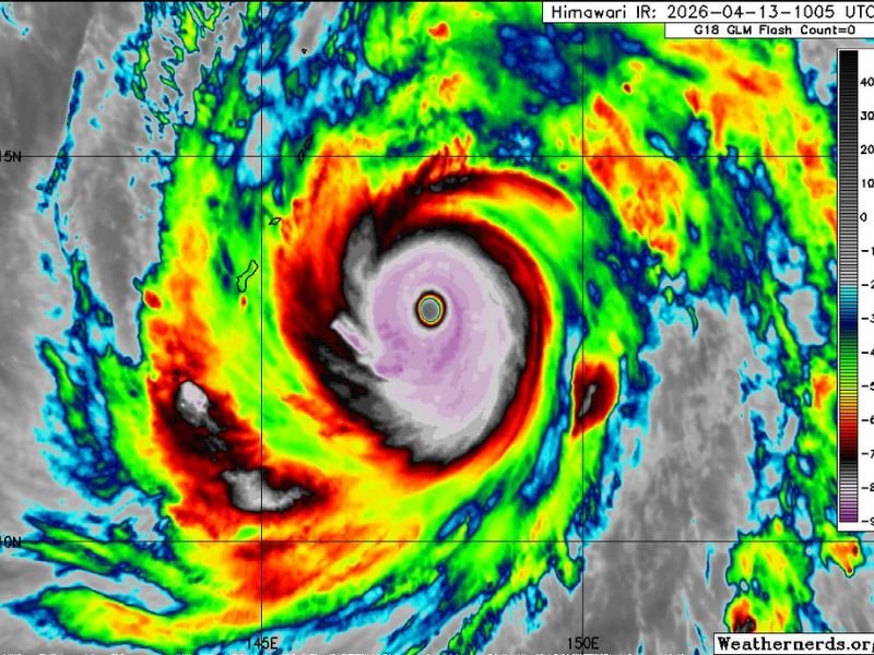
Category 5 Monster Closing In Fast
Satellite imagery captured on April 13, 2026 tells a chilling story — a perfectly organized, textbook Category 5 super typhoon with a clearly defined eye wall bearing down on the Mariana Islands chain. Winds of 175 mph place Sinlaku at the absolute top tier of tropical cyclone intensity, capable of near-total destruction across any landmass it directly strikes.
This is not a storm to ride out or take chances with. Anyone remaining on Saipan and Tinian who has not yet completed emergency preparations must do so immediately before conditions deteriorate beyond the point of safe movement.
Saipan and Tinian Face Direct and Catastrophic Impact
Both islands are squarely in the path of Sinlaku’s core. A direct strike at this intensity brings catastrophic wind damage, life-threatening storm surge inundating coastal areas, and torrential rainfall that will push every boundary. All residents must be sheltered before the storm arrives — the window for safe action is closing rapidly.
Guam Will Not Take a Direct Hit — But Stay Alert
For the many people with family and friends stationed on Guam, there is some relief — Sinlaku is not expected to make direct landfall there. However, tropical storm conditions remain likely through Wednesday, bringing gusty winds, heavy rainfall, and dangerously rough seas to the island.
Guam will fare considerably better than Saipan and Tinian, but residents and military personnel should not underestimate the situation. Tropical storm force winds and heavy rain can still cause significant damage, flooding, and hazardous conditions. Appropriate preparations should be firmly in place before the system’s outer bands begin affecting the island.
Philippines Remains Out of Harm’s Way
Forecasters have confirmed that Sinlaku’s track will not bring the system into contact with the Philippines. Residents and those with loved ones there can take comfort knowing this storm poses no threat to the Philippine archipelago.
All eyes remain locked on Saipan and Tinian as this catastrophic super typhoon closes in. Every minute counts — complete preparations now, get to shelter, and do not wait. Stay with NapervilleLocal.com for the latest weather updates and local forecast coverage.

I’ve lived in Naperville long enough to see how quickly our community changes — from new developments downtown to sudden shifts in our Midwest weather. Reporting on Naperville news and daily forecasts gives me the chance to keep neighbors informed about what really matters. My goal is simple: deliver clear, timely updates so you always know what’s happening in our city and what to expect from the skies above.