
All Severe Weather Modes Threaten Tulsa, Stillwater, and Northeast Oklahoma This Afternoon — Large Hail, Tornadoes, and 7–10 PM Peak Danger
TULSA, Okla. — The atmospheric cap that held storms back yesterday is breaking down today, unleashing a significant all-modes severe weather event across Oklahoma. Storms will fire across western and central Oklahoma this afternoon before pushing into northeastern Oklahoma and southeast Kansas this evening. The most dangerous window is concentrated near and north of Tulsa between 7 and 10 PM, with an additional overnight round possible between 11 PM and 3 AM Wednesday.
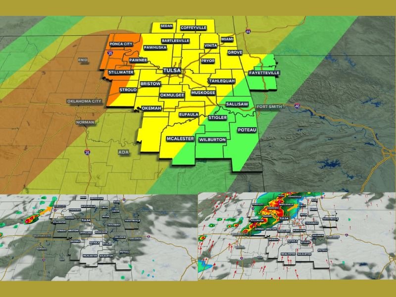
Storms Develop by 4 PM — Peak Threat 7 to 10 PM
Storm clusters are expected to intensify across western and central Oklahoma by 4 PM before the severe threat shifts into northeastern Oklahoma after 6 PM. The highest concentration of dangerous activity is forecast near Tulsa, Ponca City, Stillwater, Bartlesville, Pawhuska, Pawnee, and Pryor during the 7 to 10 PM window.
Lesser but still meaningful severe weather chances extend southward through Bristow, Stroud, Okmulgee, Muskogee, McAlester, and Wilburton through the evening hours. Southeastern Oklahoma carries lower but not zero threat, and forecasters are remaining on guard areawide.
Every Severe Weather Mode Is on the Table
Large hail, damaging winds, tornadoes, and localized flooding are all possible as storms push through the region. The storm zone map shows a high threat level centered directly over the Tulsa metro, with a moderate threat extending outward across northeastern Oklahoma into southeast Kansas near Coffeyville, Sedan, and Bartlesville.
No single hazard dominates today — residents need to be simultaneously prepared for all threats as storms move through their specific area during the evening hours.
Overnight Round Possible 11 PM Through 3 AM Wednesday
The threat does not end with the evening storms. An additional cluster of strong to severe storms could push back into northeastern Oklahoma overnight, arriving between 11 PM and 3 AM Wednesday morning. Residents should keep weather alerts active through the night and have shelter plans ready even after going to bed.
Have multiple ways to receive warnings, review your severe weather safety plan right now, and do not wait until storms are on top of you to take action. Stay with NapervilleLocal.com for the latest weather updates and local forecast coverage.

I’ve lived in Naperville long enough to see how quickly our community changes — from new developments downtown to sudden shifts in our Midwest weather. Reporting on Naperville news and daily forecasts gives me the chance to keep neighbors informed about what really matters. My goal is simple: deliver clear, timely updates so you always know what’s happening in our city and what to expect from the skies above.