
Enhanced Risk Severe Weather Threatens Chicago, Madison, Milwaukee, and Rockford This Afternoon With Three Possible Dangerous Outcomes on the Table
CHICAGO, Ill. — The entire area from Cedar Rapids and Dubuque through Madison, Milwaukee, Rockford, and Chicago remains under a Level 3 of 5 Enhanced Risk for severe weather this afternoon and tonight. Forecasters are describing this as a very complicated setup with three distinct potential outcomes — ranging from isolated supercells with tornadoes to a widespread damaging wind event, or both scenarios occurring simultaneously. The cap remains the wild card that will ultimately determine which outcome plays out.
Three Possible Outcomes — All Dangerous
Outcome #1 sees the cap breaking between 4 and 10 PM, triggering isolated to widely scattered supercells capable of very large hail, tornadoes, and gusty winds. This is the most dangerous scenario for the region.
Outcome #2 sees storms failing to fire in the afternoon, with a more organized complex arriving later in the evening bringing widespread gusty winds as the main threat, along with some hail and brief weaker tornadoes.
Outcome #3 — the least likely but not impossible scenario — sees both outcomes occurring back to back, raising additional concerns for localized to potentially widespread flash flooding on top of all other hazards.
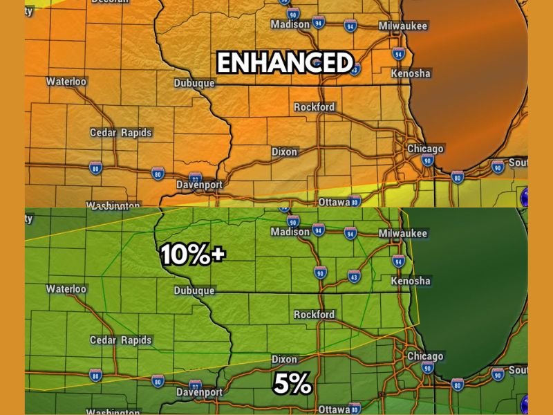
Threat Breakdown — Hail, Tornadoes, and Damaging Winds
Large hail carries a 30% probability across the core zone covering Madison, Milwaukee, Dubuque, and Rockford. The tornado risk sits at 10%+ for the same area, dropping to 5% further south toward Davenport and Ottawa. Damaging winds carry a significant 15% probability across the broader corridor, with forecasters labeling the wind threat as significant for the Chicago metro and surrounding communities.
What Residents Need to Do Right Now
With three potential scenarios still in play, residents across the entire Enhanced Risk zone should not wait for certainty before preparing. Have your shelter location identified, keep multiple ways to receive weather warnings active, and stay tuned for updates as the cap situation becomes clearer through the early afternoon hours. Stay with NapervilleLocal.com for the latest weather updates and local forecast coverage.

I’ve lived in Naperville long enough to see how quickly our community changes — from new developments downtown to sudden shifts in our Midwest weather. Reporting on Naperville news and daily forecasts gives me the chance to keep neighbors informed about what really matters. My goal is simple: deliver clear, timely updates so you always know what’s happening in our city and what to expect from the skies above.