
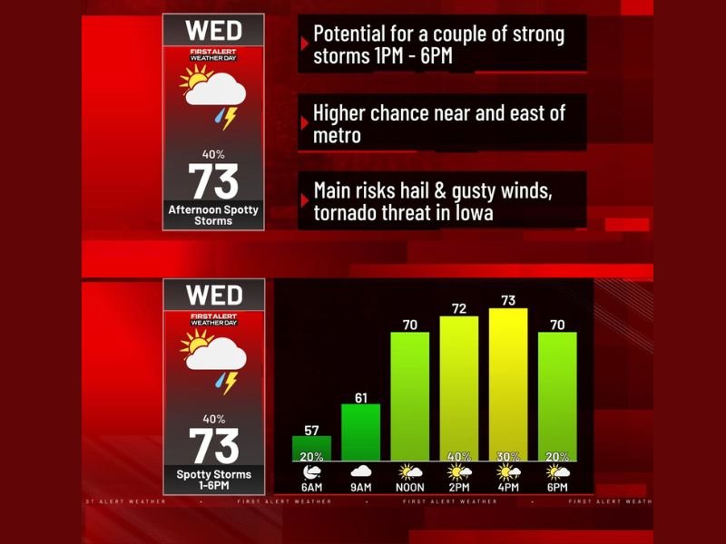
Iowa and Metro Area Face Severe Storm Threat Wednesday 1–6 PM With Hail, Gusty Winds, and Tornado Risk
IOWA — A First Alert Weather Day is in effect for Wednesday across the metro area and into Iowa, as forecasters warn of the potential for a couple of strong and possibly severe storms during the afternoon. The primary window of concern runs from 1 p.m. to 6 p.m., and while many residents will stay dry, any storm that does develop carries the potential to turn dangerous quickly.
Afternoon Hours Carry the Greatest Storm Potential
Storm chances remain low through the morning, sitting around 20% at 6 a.m. and through 9 a.m., before climbing sharply to 40% by noon and holding through the early afternoon peak window. Temperatures will rise steadily alongside the storm threat, starting near 57°F in the morning and climbing to 61°F by 9 a.m., 70°F by noon, 72°F by 2 p.m., and topping out near 73°F by 4 p.m. — right in the middle of the most active period.
Higher Storm Chances Near and East of the Metro
Not all areas carry equal risk on Wednesday. Forecasters are pointing to locations near and east of the metro as the zone most likely to see storm activity during the afternoon window. Residents in those areas should have a plan in place and stay tuned to weather updates throughout the day, as conditions can change quickly when spotty storm development is in play.
Hail and Gusty Winds Are the Primary Threats
For anyone who encounters a storm Wednesday afternoon, hail and gusty winds represent the two most significant hazards. These types of severe weather can develop rapidly and cause damage with little warning. Outdoor plans, travel, and any activities scheduled between 1 p.m. and 6 p.m. should be approached with flexibility, particularly for those located closer to and east of the metro corridor.
Tornado Threat Elevated Across Iowa
While the metro area faces a general severe storm risk, the tornado threat on Wednesday is most pronounced across Iowa. Atmospheric conditions there are expected to be more favorable for rotating storms during the afternoon hours. Anyone with family, travel plans, or connections to areas in Iowa should monitor local alerts closely and be prepared to take shelter if warnings are issued.
Most Residents Stay Dry, But Preparedness Is Key
Despite the First Alert designation, the majority of residents will not see a storm Wednesday. However, because the storms that do develop carry the potential to be severe, forecasters are urging everyone to remain aware and have a safety plan ready during the 1 p.m. to 6 p.m. window. Stay with NapervilleLocal.com for the latest weather updates and local forecast coverage.

I’ve lived in Naperville long enough to see how quickly our community changes — from new developments downtown to sudden shifts in our Midwest weather. Reporting on Naperville news and daily forecasts gives me the chance to keep neighbors informed about what really matters. My goal is simple: deliver clear, timely updates so you always know what’s happening in our city and what to expect from the skies above.