
Northern Ohio Faces Severe Thunderstorms Risk Wednesday 2–11 PM With 60-70 MPH Wind Gusts, Large Hail, and Isolated Tornado Threat
OHIO — A Slight Risk for severe thunderstorms is in place across the northern third of Ohio this Wednesday, April 15, 2026, with a Marginal Risk extending along and just south of the I-70 corridor. Two rounds of thunderstorms are expected to develop through the afternoon and evening hours, with some storms reaching severe levels. Residents across the affected zone are urged to prepare now and not wait for warnings to act.
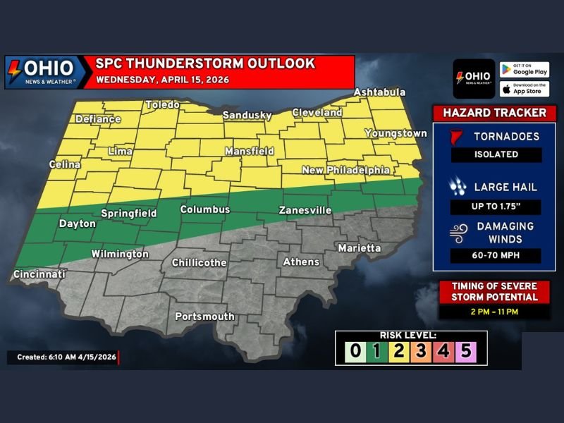
Storm Timing Runs From 2 PM Through 11 PM
The severe weather threat will kick off around 2 p.m. and continue through 11 p.m. Wednesday evening. The first round of storms is expected to initiate across Northwest Ohio before tracking eastward through the afternoon. A second round may then develop in the wake of the first later in the evening, extending the window of concern well into the night for portions of the state.
Primary Threats Include Damaging Winds, Large Hail, and Isolated Tornadoes
The hazard tracker identifies three key threats with Wednesday’s storm system. Damaging wind gusts in the 60 to 70 MPH range represent the most significant and widespread danger. Large hail up to 1.75 inches in diameter is also possible with the stronger storms that form. Additionally, an isolated tornado cannot be ruled out, particularly across the northern third of the state where atmospheric conditions are most unstable.
Morning Storms Could Complicate Afternoon Development
Forecasters note that morning rain and storm activity across Northern Ohio could both help and hinder later severe storm development. Sufficient sunshine will be needed during the midday hours to destabilize the atmosphere and provide the fuel necessary for afternoon storm intensification.
Model data has shown some inconsistency with this type of conditional setup, though enough wind shear and atmospheric dynamics remain in place to support at least isolated severe thunderstorm development regardless of morning cloud cover.
Northern Ohio Under Slight Risk, I-70 Corridor at Marginal Risk
The SPC Thunderstorm Outlook places the northern third of Ohio — including Toledo, Sandusky, Cleveland, Mansfield, Youngstown, and surrounding areas — under a Slight Risk, represented as a Level 2 out of 5 on the risk scale. Areas along and south of the I-70 corridor, including Columbus, Zanesville, Dayton, and Springfield, fall under a Marginal Risk designation. Southern counties including Cincinnati, Chillicothe, Athens, and Portsmouth are not included in the primary risk zone at this time.
Prepare Now and Have Multiple Ways to Receive Alerts
Forecasters are urging residents across Ohio to take preparedness steps immediately and not wait until a warning is issued for their specific area. Sirens alone should not be relied upon as the sole source of severe weather notification. Having multiple ways to receive alerts — including a weather app, battery-powered radio, or wireless emergency alerts on a mobile device — is strongly recommended heading into this afternoon and evening. Stay with NapervilleLocal.com for the latest weather updates and local forecast coverage.

I’ve lived in Naperville long enough to see how quickly our community changes — from new developments downtown to sudden shifts in our Midwest weather. Reporting on Naperville news and daily forecasts gives me the chance to keep neighbors informed about what really matters. My goal is simple: deliver clear, timely updates so you always know what’s happening in our city and what to expect from the skies above.