
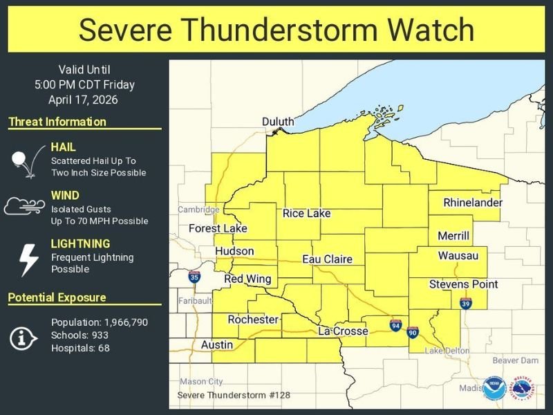
Severe Thunderstorm Watch Issued for Minnesota and Wisconsin Until 5 PM Friday With Two-Inch Hail, 70 MPH Gusts, and Frequent Lightning Threatening Nearly 2 Million Residents
MINNESOTA AND WISCONSIN — A Severe Thunderstorm Watch has been issued for portions of Minnesota and Wisconsin, valid until 5:00 PM CDT this Friday, April 17, 2026. The watch covers a broad and heavily populated zone across both states, with scattered large hail up to two inches in size, isolated damaging wind gusts up to 70 MPH, and frequent lightning all listed as primary threats. Nearly 2 million residents, 933 schools, and 68 hospitals fall within the watch area.
Watch Zone Covers Major Communities Across Both States
The Severe Thunderstorm Watch zone spans a significant portion of Minnesota and Wisconsin, covering communities including Duluth, Forest Lake, Hudson, Red Wing, Rochester, Austin, Rice Lake, Eau Claire, La Crosse, Rhinelander, Merrill, Wausau, and Stevens Point.
The watch area stretches from the Minnesota border communities near Cambridge and Faribault eastward through central Wisconsin all the way to Rhinelander and Stevens Point, covering a geographically large and densely populated corridor across both states.
Two-Inch Hail and 70 MPH Wind Gusts Are Primary Threats
Two significant severe weather hazards are associated with today’s watch. Scattered hail up to two inches in diameter is possible with the stronger storms, a size capable of causing damage to vehicles, rooftops, siding, and any property left exposed outdoors during storm passage.
Isolated wind gusts up to 70 MPH represent the second major hazard, with the potential to down trees, snap branches, damage structures, and knock out power across portions of the watch zone. Frequent lightning rounds out the threat, adding additional danger for anyone caught outdoors during storm activity.
Nearly 2 Million Residents and Critical Infrastructure at Risk
The scale of today’s watch is significant in terms of population exposure. Nearly 1,966,790 residents fall within the warned area, alongside 933 schools and 68 hospitals. The inclusion of that many critical facilities underscores the importance of having severe weather protocols in place across the region before storms develop.
School administrators, hospital staff, and public safety officials across the watch zone should ensure their severe weather action plans are active and ready for implementation through the 5 PM expiration of the watch.
Remain Alert Through 5 PM CDT Friday
The watch remains valid through 5:00 PM CDT Friday, meaning storm development and severe weather impacts could continue through the late afternoon hours across Minnesota and Wisconsin. Residents across the watch zone should monitor conditions closely and be prepared to take shelter immediately if warnings are issued for their specific location.
Have multiple ways to receive weather alerts active, stay aware of changing conditions throughout the afternoon, and avoid unnecessary outdoor activities until the watch expires or conditions improve across the region. Stay with NapervilleLocal.com for the latest weather updates and local forecast coverage.

I’ve lived in Naperville long enough to see how quickly our community changes — from new developments downtown to sudden shifts in our Midwest weather. Reporting on Naperville news and daily forecasts gives me the chance to keep neighbors informed about what really matters. My goal is simple: deliver clear, timely updates so you always know what’s happening in our city and what to expect from the skies above.