
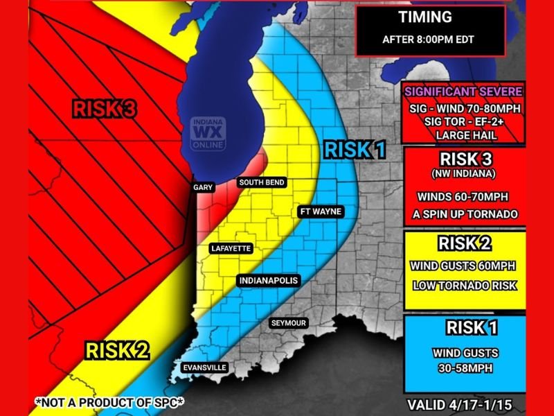
Damaging Winds 60-70 MPH and Spin-Up Tornado Threat Targeting Northwest Indiana Including Gary and South Bend Tonight After 8 PM Through 4 AM
NORTHWEST INDIANA — A severe weather threat is moving toward Indiana tonight as a fast-moving line of storms pushes eastward from Illinois after 8:00 PM EDT and continues through 4:00 AM EDT. Northwest Indiana faces the highest confidence in severe weather tonight, with damaging winds of 60 to 70 MPH, a spin-up tornado threat, and hail up to one inch all possible before the line begins weakening as it approaches the I-69 corridor. Areas further east across the state will see a rapidly weakening system with gusty outflow winds of 30 to 58 MPH.
Northwest Indiana Faces the Greatest Severe Risk Tonight
The IWO Severe Outlook places Northwest Indiana under a Risk 3 designation, the highest level on tonight’s outlook map for the state. Communities including Gary, South Bend, and surrounding northwest Indiana communities sit squarely within this highest risk zone after 8 PM tonight.
Model guidance indicates the storm line may still hold significant intensity as it crosses into northwest Indiana before weakening ahead of the I-69 corridor. Residents in Gary, South Bend, and surrounding northwest Indiana communities should be fully prepared and sheltered before 8 PM tonight.
Three Specific Hazards Identified for Northwest Indiana
Forecasters have identified three distinct hazards for the Northwest Indiana Risk 3 zone tonight. Damaging wind gusts of 60 to 70 MPH represent the primary and most widespread threat, capable of downing trees, snapping power lines, and causing structural damage across the impacted corridor.
A spin-up tornado cannot be ruled out as the line moves through, adding a second significant hazard to an already dangerous setup. Hail up to one inch in diameter rounds out the threat picture for northwest Indiana, with all three hazards possible during the 8 PM to 4 AM window.
Storm Line at Its Strongest in Illinois Before Entering Indiana
The storm system currently developing across the upper Midwest will reach peak intensity across Illinois before crossing into Indiana tonight. Isolated supercells are expected to grow upscale into a fast-moving squall line as they push into northern and central Illinois, where wind gusts of 60 to 80 MPH and spin-up tornadoes are possible during the Illinois passage.
Gradual weakening is then expected as the line tracks eastward toward Indiana, though northwest Indiana retains the highest confidence in holding onto severe intensity before the line loses steam ahead of I-69.
Central and Southern Indiana Face Risk 2 and Risk 1 Conditions
As the storm line pushes further east across Indiana, rapid weakening is expected to significantly reduce the severe threat. Indianapolis, Lafayette, and surrounding central Indiana communities fall under a Risk 2 designation, where 60 MPH wind gusts and a low tornado risk remain possible but confidence is lower than the northwest zone.
Areas further east including Fort Wayne, Seymour, and Evansville fall under the Risk 1 category, where strong to damaging winds of 30 to 58 MPH represent the primary hazard as the line continues to weaken during its eastward progression through the overnight hours.
Be Sheltered and Alert Before 8 PM Tonight
With the storm window opening at 8 PM EDT, residents across northwest Indiana have limited time remaining to finalize severe weather preparations. Identify interior shelter locations on the lowest floor of sturdy structures, activate multiple weather alert systems, and avoid unnecessary travel after 8 PM through the overnight hours.
Do not wait for warnings to be issued before taking action tonight, as the fast-moving nature of squall lines can produce very short warning lead times for spin-up tornadoes and sudden damaging wind events. Stay with NapervilleLocal.com for the latest weather updates and local forecast coverage.

I’ve lived in Naperville long enough to see how quickly our community changes — from new developments downtown to sudden shifts in our Midwest weather. Reporting on Naperville news and daily forecasts gives me the chance to keep neighbors informed about what really matters. My goal is simple: deliver clear, timely updates so you always know what’s happening in our city and what to expect from the skies above.