
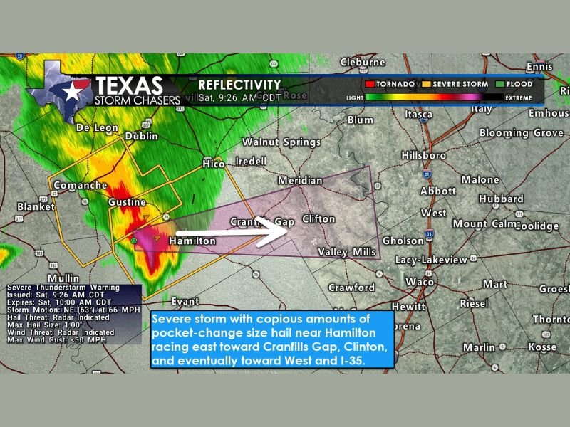
Severe Thunderstorm Racing 65 MPH East-Northeast From Hamilton Toward Cranfills Gap, Clifton, and I-35 Corridor With One-Inch Hail and Heavy Rain Saturday Morning
CENTRAL TEXAS — A severe thunderstorm near Hamilton is racing east-northeast at approximately 65 MPH as of 9:26 AM CDT this Saturday morning, April 18, 2026, prompting a Severe Thunderstorm Warning valid until 10:00 AM CDT. The fast-moving storm is capable of producing hail up to one inch in diameter, frequent lightning, and brief heavy rainfall as it tears through central Texas. Communities including Cranfills Gap, Clifton, and Valley Mills are directly in the storm’s path, with the I-35 corridor near West also potentially in line if the storm holds together through its eastward trek.
Storm Racing at 65 MPH Toward Cranfills Gap and Clifton
The severe thunderstorm is moving at an unusually fast 65 MPH in a east-northeast direction, meaning communities in its path have extremely limited time between the issuance of the warning and the storm’s actual arrival. Cranfills Gap and Clifton are the most immediately threatened communities based on the storm’s current track and speed.
The rapid movement of the cell compresses the warning window significantly, leaving residents in its direct path only minutes to take protective action after becoming aware of the storm. Anyone in Cranfills Gap, Clifton, or Valley Mills should seek shelter immediately and not wait to see the storm approaching before acting.
One-Inch Hail and 50 MPH Wind Gusts Possible
The Severe Thunderstorm Warning details confirm two primary hazards with this storm. Radar-indicated hail up to one inch in diameter — roughly pocket-change size — is possible with the strongest part of the cell as it moves through the warned area.
Maximum wind gusts up to 50 MPH are also radar-indicated with the storm, capable of causing minor tree damage, moving lightweight outdoor items, and creating briefly hazardous driving conditions across communities in the cell’s immediate path. Frequent lightning and brief but heavy rainfall will accompany both hazards throughout the storm’s passage.
I-35 Corridor Near West Could Be Impacted if Storm Holds Together
Beyond the immediate impact communities of Cranfills Gap, Clifton, and Valley Mills, the storm track points toward the I-35 corridor near the city of West if the cell maintains its current intensity and organization through its eastward progression. Motorists traveling along I-35 through central Texas this morning should be aware of the approaching system and be prepared for sudden deteriorating conditions including reduced visibility and gusty winds.
The storm’s eventual approach toward the I-35 corridor is conditional on it holding together as it races east-northeast, but given its current intensity on radar the possibility should not be dismissed by residents and travelers in that zone.
Warning Expires at 10:00 AM CDT
The Severe Thunderstorm Warning for this cell is valid until 10:00 AM CDT Saturday morning. Given the storm’s forward speed of 65 MPH, impacts across warned communities will be brief but intense before the system exits the area and the warning expires.
Residents across Hamilton, Cranfills Gap, Clifton, Valley Mills, and the broader I-35 corridor should remain weather aware through the warning expiration time and monitor updated radar and warning information closely as the fast-moving storm continues its east-northeast track through central Texas. Stay with NapervilleLocal.com for the latest weather updates and local forecast coverage.

I’ve lived in Naperville long enough to see how quickly our community changes — from new developments downtown to sudden shifts in our Midwest weather. Reporting on Naperville news and daily forecasts gives me the chance to keep neighbors informed about what really matters. My goal is simple: deliver clear, timely updates so you always know what’s happening in our city and what to expect from the skies above.