
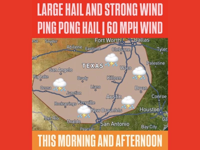
Large Hail Up to Ping Pong Ball Size and 60 MPH Wind Gusts Threatening Central Texas From Waco to San Antonio and Austin Through Saturday Afternoon
CENTRAL TEXAS — Severe storms are ongoing this Saturday morning across central Texas and the isolated severe risk is expected to continue through the afternoon hours across a broad zone stretching from the Hill Country northward through Waco and the Austin corridor.
Elevated storms developing behind the cold front are capable of producing quarter to half-dollar size hail, with an isolated instance of ping pong ball size hail that cannot be ruled out. Wind gusts up to 60 MPH are also possible with the strongest storms, though a tornado risk is not a concern with this post-frontal setup.
Broad Risk Zone Covers Central Texas From Hill Country to Waco
The severe weather risk zone covers a wide swath of central Texas this morning and afternoon, encompassing a large corridor from the Hill Country and San Angelo area northeastward through Brady, Llano, Kerrville, New Braunfels, San Antonio, Austin, Killeen, Waco, and toward the Cleburne and Fort Worth southern suburbs.
Communities including Junction, Rocksprings, Uvalde, Ozona, and Big Lake in the west through Bryan, Palestine, and eastward also fall within the outlined risk area. The broad geographic footprint of today’s threat means that millions of central Texas residents face at least some risk of encountering a severe storm through the afternoon hours.
Quarter to Half-Dollar Hail With Isolated Ping Pong Ball Size Possible
The primary severe weather hazard with today’s storms is large hail. Quarter to half-dollar size hail is expected with the elevated storms developing behind the cold front, representing a meaningful hail threat to vehicles, rooftops, and outdoor property across the affected corridor.
More concerning is the isolated possibility of ping pong ball size hail with the strongest cells that develop. Ping pong ball size hail can cause significant vehicle damage and poses a real danger to anyone caught outdoors during a storm’s passage. Residents across the risk zone should be prepared to move vehicles to covered parking if storm activity develops in their area.
60 MPH Wind Gusts Possible With Strongest Storms
Beyond the hail threat, wind gusts up to 60 MPH are possible with the strongest storms across the central Texas risk zone this morning and afternoon. Gusts of that magnitude are capable of downing tree limbs, moving outdoor furniture and lightweight objects, and creating briefly dangerous driving conditions across the affected corridor.
The combination of large hail and gusty winds with these post-frontal storms makes them worth monitoring closely through the afternoon hours even without the tornado component that has been associated with recent severe weather events across the broader region.
No Tornado Risk With This Post-Frontal Setup
One notable and reassuring aspect of today’s severe weather setup is the absence of a tornado threat. Because today’s storms are developing behind the cold front rather than ahead of it, the atmospheric dynamics do not support tornado development with this particular system.
The post-frontal environment lacks the wind shear and instability profiles necessary for rotating storms, meaning residents can focus their preparedness efforts on the hail and wind hazards without the additional concern of tornado warnings that have dominated the region’s severe weather coverage throughout the past week.
Stay Alert Through the Afternoon Hours
With severe storms ongoing through the morning and the isolated severe risk continuing into the afternoon, residents across central Texas from the Hill Country through Waco and Austin should remain weather aware throughout the day. Have multiple ways to receive weather alerts active, avoid unnecessary travel if storms are in your immediate area, and move vehicles to shelter if large hail becomes imminent in your location. Stay with NapervilleLocal.com for the latest weather updates and local forecast coverage.

I’ve lived in Naperville long enough to see how quickly our community changes — from new developments downtown to sudden shifts in our Midwest weather. Reporting on Naperville news and daily forecasts gives me the chance to keep neighbors informed about what really matters. My goal is simple: deliver clear, timely updates so you always know what’s happening in our city and what to expect from the skies above.