
Severe Weather Risk Builds for Birmingham and Northern Alabama Monday April 27 With Heavy Storms Friday Night and Scattered Thunderstorms Saturday Also in the Forecast
ALABAMA — A multi-day severe weather threat is developing for Alabama this week, with the most significant long-range concern centered on Monday April 27 when the NOAA Storm Prediction Center Day 7 Outlook places a significant portion of Alabama including Birmingham and areas to the north in a 15 to 29% risk area for severe weather. Before Monday arrives, heavy storms are likely Friday night into Saturday morning, with scattered thunderstorms expected Saturday afternoon and a potential break on Sunday with most storm activity staying closer to the Gulf Coast.
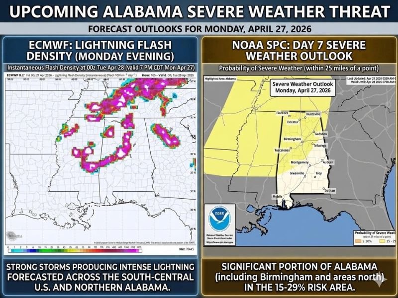
Monday April 27 Draws the Most Concern for Northern Alabama
The SPC Day 7 Severe Weather Outlook for Monday April 27 highlights a broad swath of northern and central Alabama in the 15 to 29% severe weather probability zone. Communities including Birmingham, Huntsville, Florence, Decatur, Gadsden, Tuscaloosa, Talladega, Montgomery, Auburn, and surrounding areas all fall within the outlined risk area.
The ECMWF lightning flash density model for Monday evening shows intense storm activity with extreme lightning density forecasted across the south-central US and northern Alabama, adding further confidence to the concern that Monday will be a significant severe weather day for the state.
Weekend Storm Timeline Starts Friday Night
Before Monday’s threat materializes, Alabama faces an active weekend pattern beginning Friday night. Heavy storms are considered likely during the Friday night into Saturday morning window, with the potential for significant rainfall and embedded severe activity across portions of the state through the overnight hours.
Saturday afternoon then brings scattered thunderstorms across the region, extending the active weather period through most of the weekend. Sunday currently looks like the best day for a break, with most storm activity expected to stay closer to the Gulf Coast, which would be welcome news particularly for the Talladega area.
Monday Setup Still Uncertain but Worth Watching Closely
Forecasters are being careful to note that Monday’s severe weather potential is still seven days out and the exact setup and timing remain unclear. Whether Monday constitutes a full outbreak or a more limited severe weather event has not yet been determined, and residents are being asked to stay plugged in to updated forecasts rather than drawing conclusions from the early outlook data alone.
What is clear is that enough model agreement exists at this range to warrant keeping Monday on the radar as a day of concern for Birmingham and northern Alabama heading into next week.
Prepare Now for an Active End of the Week and Weekend
With the active weather pattern beginning as early as Friday night, Alabama residents should begin preparedness steps now rather than waiting until the threat is imminent. Ensure weather alert systems are active, have shelter plans ready, and monitor daily forecast updates as the week progresses and confidence in both the weekend and Monday threats increases. Stay with NapervilleLocal.com for the latest weather updates and local forecast coverage.

I’ve lived in Naperville long enough to see how quickly our community changes — from new developments downtown to sudden shifts in our Midwest weather. Reporting on Naperville news and daily forecasts gives me the chance to keep neighbors informed about what really matters. My goal is simple: deliver clear, timely updates so you always know what’s happening in our city and what to expect from the skies above.