
Very Large Hail and Damaging Winds Threatening Iowa, Nebraska, and Kansas Thursday April 23 With Level 2 Risk Stretching From Fargo to Oklahoma City
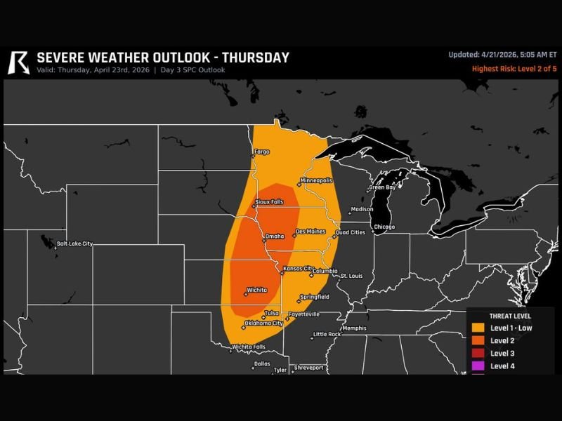
IOWA, NEBRASKA, AND KANSAS — Severe thunderstorms capable of very large hail and damaging winds are possible across a broad corridor of the central United States this Thursday April 23, 2026, as the SPC Day 3 Outlook places a significant portion of the Plains and Midwest under an elevated severe weather risk. The highest risk reaches Level 2 out of 5, centered across a corridor from Fargo and Minneapolis southward through Sioux Falls, Omaha, Des Moines, Kansas City, Wichita, and down toward Oklahoma City and Tulsa.
Level 2 Risk Covers the Core Threat Corridor
The Severe Weather Outlook valid for Thursday April 23 shows a Level 2 Slight Risk zone covering the primary threat corridor across the central United States. The core of the risk area is concentrated across Iowa, Nebraska, Kansas, and Missouri, with the threat extending northward into Minnesota and South Dakota and southward into Oklahoma and northern Texas.
Communities including Fargo, Minneapolis, Sioux Falls, Omaha, Des Moines, Quad Cities, Kansas City, Columbia, Springfield, Wichita, Tulsa, Oklahoma City, and Fayetteville all fall within the outlined risk zone for Thursday’s severe weather potential.
Very Large Hail and Damaging Winds Are Primary Hazards
The two dominant hazards with Thursday’s severe thunderstorm potential are very large hail and damaging winds. Very large hail capable of causing significant damage to vehicles, rooftops, and outdoor property is possible with the strongest storms that develop along the cold front and dryline pushing through the region.
Damaging wind gusts accompanying the storm system add a second widespread hazard across the entire risk corridor, with the potential for downed trees, power line damage, and dangerous travel conditions during peak storm activity Thursday afternoon and evening.
Storms Develop Along Cold Front and Dryline
The severe weather setup for Thursday is driven by a cold front and dryline interacting across the central Plains, providing the lift and instability needed to trigger storm development across the outlined risk corridor. Initial storms may develop as discrete supercells before transitioning into more organized storm modes as the day progresses.
The supercell phase early in the event carries the greatest potential for very large hail, while the organized squall line phase that develops later will be responsible for the widespread damaging wind threat across the broader corridor.
Have a Safe Room Identified Before Thursday
Forecasters are specifically urging all residents across the Thursday risk corridor to have a way to receive weather alerts active and a safe room or shelter location identified before Thursday’s storm window opens. The broad geographic scope of the Level 2 risk zone means that millions of residents across multiple states need to be prepared for the possibility of severe thunderstorm warnings impacting their specific location during the day. Stay with NapervilleLocal.com for the latest weather updates and local forecast coverage.

I’ve lived in Naperville long enough to see how quickly our community changes — from new developments downtown to sudden shifts in our Midwest weather. Reporting on Naperville news and daily forecasts gives me the chance to keep neighbors informed about what really matters. My goal is simple: deliver clear, timely updates so you always know what’s happening in our city and what to expect from the skies above.