
Heavy Rainfall of 2-4 Inches Expected Across Birmingham and Huntsville This Weekend With Best Storm Chance Friday Night Through Early Saturday Morning
ALABAMA — Forecast confidence is increasing for a significant rainfall event across Alabama this weekend, with the best storm window now coming into focus as Friday night through early Saturday morning. The 7-day total rainfall forecast valid through April 28, 2026 shows impressive accumulations across the northern half of the state, with Birmingham and Huntsville both expected to see 2 to 3 inches, western Alabama potentially picking up 3 to 4 inches, and a limited risk of severe weather mainly from wind along with intense lightning during the primary Friday night storm batch.
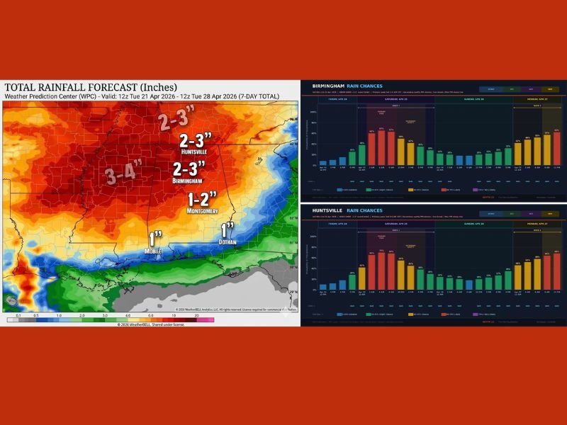
7-Day Rainfall Totals Show Impressive Accumulations Statewide
The Weather Prediction Center 7-day rainfall forecast map paints a significant precipitation picture across Alabama. Western portions of the state are forecast to see the highest totals at 3 to 4 inches, while Birmingham and Huntsville are both in the 2 to 3 inch range. Montgomery is forecast to pick up 1 to 2 inches, with southern communities including Mobile and Dothan receiving around 1 inch through the seven-day period.
Forecasters note this is one of the stronger rainfall confidence signals seen in the 7-day window in quite some time, suggesting the overall precipitation outcome is more certain than typical extended range forecasts for the region.
Friday Night Into Early Saturday Morning Is the Primary Window
As of Wednesday morning, the best chance for the heaviest rainfall and storm activity has narrowed to Friday night through early Saturday morning. This timing update gives residents a clearer picture of when to expect the most significant impacts from the weekend weather system.
A limited risk of severe weather exists with this batch, primarily from damaging wind gusts rather than tornadoes. Intense lightning will also accompany the Friday night storms, making it important for residents to be indoors and away from outdoor activities during the peak storm window.
Birmingham and Huntsville Rain Chance Graphs Show Multi-Wave Setup
The hourly rain chance graphs for both Birmingham and Huntsville show a multi-wave precipitation setup developing across Friday, Saturday, and into Monday. Multiple rounds of rain chances are visible across the three-day period, with the highest probability bars concentrated during the Friday night and early Saturday morning timeframe consistent with the primary storm window identified by forecasters.
Additional rain chances on Sunday and Monday will contribute to the impressive 7-day totals being forecast across northern Alabama, keeping the overall wet pattern active well into next week.
Drought Relief on the Way for Parched Alabama
The combination of multiple rainfall rounds through the weekend and into next week represents meaningful drought relief for Alabama, which has been dealing with abnormally dry conditions as part of the broader national drought pattern. The 2 to 4 inch totals forecast across northern Alabama would make a noticeable dent in the moisture deficit that has been building across the state throughout the spring season. Stay with NapervilleLocal.com for the latest weather updates and local forecast coverage.

I’ve lived in Naperville long enough to see how quickly our community changes — from new developments downtown to sudden shifts in our Midwest weather. Reporting on Naperville news and daily forecasts gives me the chance to keep neighbors informed about what really matters. My goal is simple: deliver clear, timely updates so you always know what’s happening in our city and what to expect from the skies above.