
TORCON 5 Issued for Metro Wichita and Kansas Today With Tornadoes Expected Late Afternoon and 2-Inch Plus Hail as Active Severe Day Unfolds
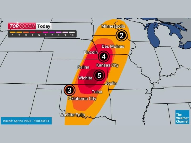
KANSAS AND SURROUNDING REGION — The Weather Channel TORCON index has been updated to its highest level of 5 for portions of Kansas including Metro Wichita as of 5:00 AM April 23, 2026, indicating a significant tornado threat developing later today.
The TORCON remains at 4 across the broader Kansas and Nebraska corridor including Kansas City and Lincoln, drops to 3 across Oklahoma City and surrounding areas, and sits at 2 across the Minneapolis zone. Tornadoes are expected to form by late afternoon and early evening, with large hail 2 inches in diameter or larger also anticipated across the risk corridor. Storms are then expected to weaken overnight with high winds and heavy rain becoming the main threats.
TORCON 5 Centered on Metro Wichita — Highest Risk Zone Today
The TORCON 5 designation for Metro Wichita represents the highest tornado probability on today’s map and signals a serious and credible tornado threat for the Wichita area and surrounding Kansas communities during the late afternoon and early evening hours. A TORCON of 5 out of 10 indicates a 50% probability of a tornado within 50 miles of any location within the highlighted zone.
The core red zone on the TORCON map is concentrated tightly around the Wichita area, with the deep red coloring indicating where atmospheric conditions are most favorable for tornado development and where the greatest risk of impactful tornado activity exists today.
TORCON 4 Covers Kansas City and Lincoln Corridor
Surrounding the highest risk Wichita zone, a TORCON 4 covers a broader area extending northward through Kansas City and Lincoln. This still represents a significant tornado probability and means residents across Kansas City, Salina, and the Nebraska border region should treat today’s threat seriously and have shelter plans ready well before the late afternoon storm window opens.
The TORCON 3 zone covering Oklahoma City and surrounding areas indicates a meaningful but somewhat lower tornado probability further south, where storm development is possible but slightly less certain than across the core Kansas risk zone.
Tornadoes Expected Late Afternoon and Early Evening
The timing for tornado development is focused on the late afternoon and early evening hours today across the Wichita and Kansas corridor. This afternoon timing gives residents some additional daylight hours to prepare and seek shelter before the most dangerous part of the storm window arrives, though conditions can deteriorate rapidly once storm initiation begins along the triggering boundaries.
Large hail of 2 inches in diameter or larger is also anticipated alongside the tornado threat, adding a significant property damage component to today’s severe weather hazard profile across the risk corridor.
Overnight Threat Shifts to High Winds and Heavy Rain
As the organized storm system weakens during the overnight hours, the tornado threat is expected to diminish but will be replaced by high winds and heavy rainfall as the dominant hazards through the overnight period. Residents should remain weather aware not just during the afternoon and evening tornado window but also through the overnight hours when the wind and rain threats continue across the affected region. Stay with NapervilleLocal.com for the latest weather updates and local forecast coverage.

I’ve lived in Naperville long enough to see how quickly our community changes — from new developments downtown to sudden shifts in our Midwest weather. Reporting on Naperville news and daily forecasts gives me the chance to keep neighbors informed about what really matters. My goal is simple: deliver clear, timely updates so you always know what’s happening in our city and what to expect from the skies above.