
Tornado Watch Likely Imminent for Nebraska, Iowa, and Minnesota as Mesoscale Discussion Flags EF-2 Tornado Potential With 3.5-Inch Hail and 70 MPH Winds
NEBRASKA, IOWA, AND MINNESOTA — A Mesoscale Discussion has been issued indicating a Tornado Watch is likely soon for portions of Nebraska, Iowa, Minnesota, Kansas, and Missouri, with an 80% watch probability already assigned to the discussion.
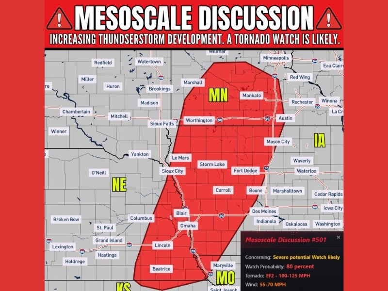
The Mesoscale Discussion covers a large red zone stretching from southern Minnesota through Iowa and into eastern Nebraska and northern Missouri, with the severe potential including EF-2 tornadoes with winds of 100 to 125 MPH, hail up to 3.50 inches in diameter, and wind gusts of 55 to 70 MPH across the outlined area.
80% Watch Probability Signals Imminent Tornado Watch Issuance
Mesoscale Discussion 501 carries an 80% probability of a Tornado Watch being issued, making the formal watch issuance essentially a near certainty across the outlined zone. The discussion cites increasing thunderstorm development across the region as the primary driver for the imminent watch, with conditions rapidly becoming favorable for organized severe storm activity across the multi-state corridor.
Communities within the red Mesoscale Discussion zone including Omaha, Sioux City, Des Moines, Fort Dodge, Storm Lake, Mankato, Minneapolis, Mason City, Lincoln, and Saint Joseph should treat a Tornado Watch as already in effect and take immediate preparedness steps.
EF-2 Tornado Potential Highlighted in Mesoscale Discussion Details
The specific severe weather parameters outlined in Mesoscale Discussion 501 are concerning and noteworthy. EF-2 tornado potential with winds of 100 to 125 MPH is explicitly identified as a threat with this developing storm system, placing this watch area in a higher-end category than a typical tornado watch.
Hail up to 3.50 inches in diameter — well above baseball size — is also anticipated with the strongest cells, representing a significant property damage threat across the watch area. Wind gusts of 55 to 70 MPH round out the three-hazard severe weather profile associated with today’s developing storm system.
Red Zone Covers Sioux City, Omaha, Des Moines, and Minneapolis Corridor
The Mesoscale Discussion zone covers a broad and heavily populated corridor across three states. In Minnesota the zone includes Minneapolis, Mankato, Worthington, and Marshall. Across Iowa the coverage includes Sioux City, Storm Lake, Fort Dodge, Mason City, Carroll, Boone, Des Moines, and Indianola. The Nebraska portion covers Omaha, Blair, Lincoln, Beatrice, Columbus, and surrounding communities, while the southern edge touches northern Missouri near Saint Joseph and Maryville.
Take Shelter Preparations Seriously Before Watch Is Issued
With the Tornado Watch issuance carrying an 80% probability, residents across the outlined multi-state zone should not wait for the formal watch before beginning preparations. Identify shelter locations now, ensure weather alerts are active on all devices, and be ready to move to shelter immediately when warnings are issued for specific locations as storm development rapidly increases across the region. Stay with NapervilleLocal.com for the latest weather updates and local forecast coverage.

I’ve lived in Naperville long enough to see how quickly our community changes — from new developments downtown to sudden shifts in our Midwest weather. Reporting on Naperville news and daily forecasts gives me the chance to keep neighbors informed about what really matters. My goal is simple: deliver clear, timely updates so you always know what’s happening in our city and what to expect from the skies above.