
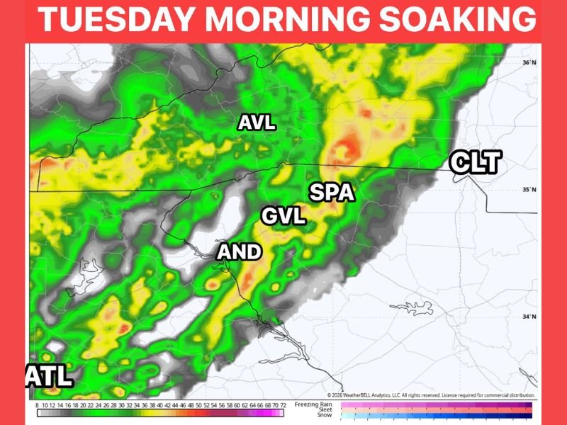
Soaking Rain Targeting the Carolinas and Georgia Including Charlotte, Greenville, and Atlanta During Morning Commute Tuesday With a Heavier Round Returning Wednesday Morning
CAROLINAS AND GEORGIA — A welcome soaking rain event is on the way for the Carolinas, Georgia, and surrounding areas across the Southeast, with the first round arriving Tuesday morning and targeting the heart of the morning commute between 7 and 11 AM. Communities including Charlotte, Greenville, Spartanburg, Asheville, Anderson, and Atlanta are all in the path of this beneficial rainfall pattern. A second and heavier round then follows Wednesday morning during the same timing window, with that event capable of delivering 0.5 to 1.5 inches of rainfall across the region.
Tuesday Morning Rain Targets the 7 to 11 AM Commute Window Across the Region
The first round of rainfall arrives Tuesday morning, with high-resolution models pinpointing the 7 to 11 AM window as the primary period of impact across the Carolinas and northern Georgia. Rainfall totals from this initial round are expected to come in around 0.25 inches, delivering a quick but meaningful soaking to communities along the corridor.
Drivers heading out during the Tuesday morning commute should expect wet roads and reduced visibility across the affected area, particularly through the Upstate South Carolina and western North Carolina corridors. The rainfall is not expected to produce severe weather concerns but will create slick conditions during the busiest travel window of the morning.
Spotty Showers Possible Tuesday Afternoon Before the Region Dries Slightly
Between the two main rainfall rounds, Tuesday afternoon will not be completely dry across the region. Spotty showers are possible through the afternoon hours, keeping conditions unsettled but not delivering any significant additional accumulations ahead of the heavier Wednesday morning event.
The spotty nature of Tuesday afternoon activity means some communities will see additional light rainfall while others remain mostly dry between the two rounds. Residents should keep a light jacket and umbrella handy through the entirety of Tuesday as shower chances persist through the day.
Heavier Second Round Arrives Wednesday Morning With Up to 1.5 Inches Possible
The Wednesday morning round follows the same general timing as Tuesday, arriving during the morning hours and targeting the commute window across the same geographic corridor. This second event is notably heavier, with rainfall totals of 0.5 to 1.5 inches possible across portions of the Carolinas and northern Georgia.
The heavier Wednesday round represents the more impactful of the two rainfall events and could cause minor ponding on roadways and localized drainage issues in areas that receive the higher end of totals. Commuters heading out Wednesday morning should plan for wet and potentially slow travel conditions across the entire region. Stay with NapervilleLocal.com for the latest weather updates and local forecast coverage.

I’ve lived in Naperville long enough to see how quickly our community changes — from new developments downtown to sudden shifts in our Midwest weather. Reporting on Naperville news and daily forecasts gives me the chance to keep neighbors informed about what really matters. My goal is simple: deliver clear, timely updates so you always know what’s happening in our city and what to expect from the skies above.