
Heavy Rain and Isolated Flood Risk Targeting Texas Including Dallas, Fort Worth, Austin, and Houston Thursday Into Friday With 1 to 3 Inch Totals Expected
NORTH, CENTRAL, AND EAST TEXAS — A significant heavy rain and flood risk setup is developing for North, Central, and East Texas Thursday into Friday, as a stalled front and incoming disturbance from Northwest Mexico combine to produce an overrunning rainfall pattern across the region.
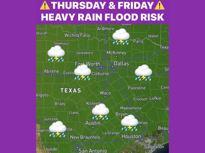
Overall rainfall totals of 1 to 3 inches are expected with isolated higher amounts possible, and water content values reaching 1.75 inches per hour create a meaningful isolated flood risk for communities including Dallas, Fort Worth, Wichita Falls, Austin, and Houston. Rain is expected to move out by Friday night, setting the stage for a sunny weekend across the state.
Stalled Front and Northwest Mexico Disturbance Combine to Trigger Heavy Rain Thursday
A cold front moving through North Texas on Tuesday will stall just south of the region by Thursday, setting up an overrunning rainfall scenario as a disturbance tracks in from Northwest Mexico into far West Texas. This combination of a stalled boundary and incoming upper-level energy is a classic setup for prolonged and locally heavy rainfall across a broad area.
Temperatures will hold in the 60s through the event, eliminating any severe weather risk and removing the capping concerns that typically limit rainfall in warmer setups. The cooler and stable environment will allow steady and persistent rainfall to develop and train over the same areas through the Thursday afternoon and overnight period.
Greatest Rainfall Forcing Arrives Thursday Afternoon Through Friday Morning
Scattered heavier rains are expected to break out Thursday afternoon with the heaviest forcing arriving through the overnight hours into Friday morning. Water content values reaching 1.75 inches per hour indicate the potential for very efficient rainfall rates during the peak of the event, which could lead to rapid water accumulation in low-lying and flood-prone areas.
The overnight timing of the heaviest rainfall is particularly concerning from a flood risk standpoint, as rising water levels can catch residents off guard during sleeping hours. Communities across North, Central, and East Texas should be aware of local flood-prone areas and avoid low-water crossings if heavy rain moves through overnight.
One to Three Inch Totals Expected With Isolated Higher Amounts Across the Region
Widespread rainfall totals of 1 to 3 inches are forecast across North, Central, and East Texas through the Thursday into Friday event, with isolated pockets of higher accumulations possible where training storm cells set up. The geographic coverage of this rainfall event makes it a good soaking for much of Texas that has been dealing with dry conditions in recent weeks.
Communities including Wichita Falls, McKinney, Dallas, Fort Worth, Waco, Austin, and Houston all fall within the primary rainfall footprint. Motorists should remain alert for flooded roadways particularly through Friday morning as rainfall totals accumulate overnight. Stay with NapervilleLocal.com for the latest weather updates and local forecast coverage.

I’ve lived in Naperville long enough to see how quickly our community changes — from new developments downtown to sudden shifts in our Midwest weather. Reporting on Naperville news and daily forecasts gives me the chance to keep neighbors informed about what really matters. My goal is simple: deliver clear, timely updates so you always know what’s happening in our city and what to expect from the skies above.