
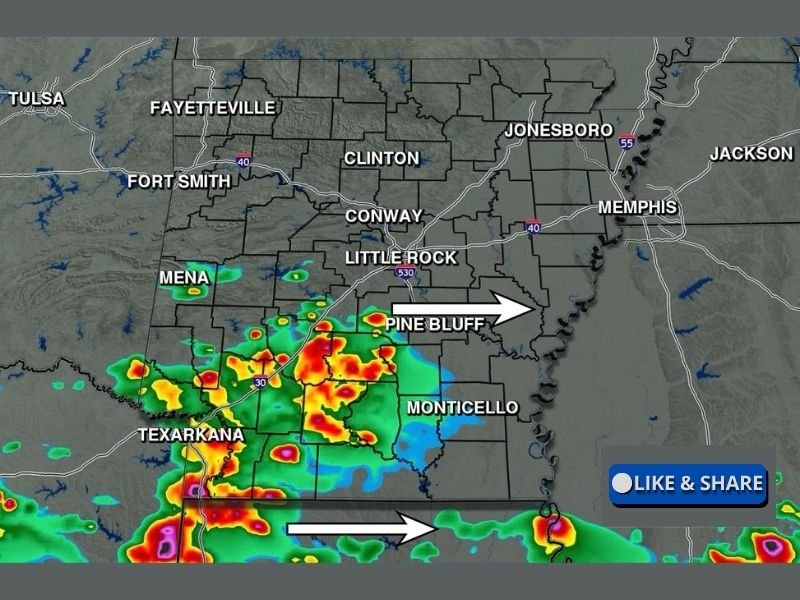
Isolated Storms With Low Hail Threat Possible Across South Arkansas Including Pine Bluff, Monticello, and Texarkana South of Little Rock This Wednesday Afternoon
SOUTH ARKANSAS — Storms are returning to the forecast for Arkansas this Wednesday afternoon, April 29, 2026, though widespread severe weather is not anticipated across the state. The storm threat is limited to the southern half of Arkansas, mainly south of Little Rock, where isolated storm development is possible through the afternoon hours. Hail would be the only real threat with any storm that develops, and even that risk is considered low, meaning the vast majority of Arkansas residents will go through today without any storm issues.
Storm Threat Confined to South of Little Rock With No Widespread Severe Risk
The futurecast map valid at 4 PM Wednesday shows storm activity concentrated across the southern tier of Arkansas, focused on communities including Pine Bluff, Monticello, and the Texarkana corridor while northern and central portions of the state including Fayetteville, Fort Smith, Jonesboro, Conway, and Little Rock remain largely dry. This represents a much more limited and localized setup compared to the active severe weather days Arkansas has experienced over the past several days.
Most of the state will see a quiet and much-needed break from the intense storm activity that has dominated the region recently. The confined nature of today’s storm threat means communities across northern and central Arkansas can expect a relatively calm Wednesday afternoon.
Hail Is the Only Potential Threat and Remains Low With Any Isolated Storm
For the southern portions of Arkansas where storm development is possible this afternoon, hail is identified as the only real potential hazard and its probability remains low. Any storms that do develop south of Little Rock will have limited severe weather support given the overall atmospheric setup today, keeping the threat well below what the region has experienced in recent days.
The low hail threat does not warrant significant concern for residents across the southern tier, but staying weather aware through the afternoon hours is still a reasonable precaution. Any storm that does develop should be monitored, as isolated cells can occasionally produce brief hazards even in low-probability environments.
Much of Arkansas Enjoys a Quiet Break After Several Days of Active Severe Weather
The vast majority of Arkansas will go through today without any thunderstorm activity, representing a welcome and well-deserved break after an extended stretch of significant severe weather events across the state and region. Communities from Fayetteville and Fort Smith through Jonesboro, Conway, and the Little Rock metro are all expected to remain dry through Wednesday afternoon.
This quieter pattern gives residents across the state an opportunity to assess any storm damage from recent events and make preparations ahead of any future weather systems that may approach the region later in the week. Stay with NapervilleLocal.com for the latest weather updates and local forecast coverage.

I’ve lived in Naperville long enough to see how quickly our community changes — from new developments downtown to sudden shifts in our Midwest weather. Reporting on Naperville news and daily forecasts gives me the chance to keep neighbors informed about what really matters. My goal is simple: deliver clear, timely updates so you always know what’s happening in our city and what to expect from the skies above.