
Substantial Rainfall of 1.5 to 2.5 Inches Forecast Across Florida Including Tampa, Jacksonville, and Panama City Over the Next 7 Days With Most Totals Arriving This Weekend
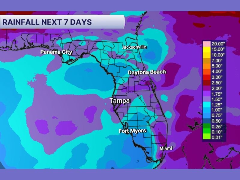
FLORIDA — A potentially drought-busting rainfall pattern is setting up across Florida over the next seven days, with the Weather Prediction Center’s 7-day rainfall accumulation map showing substantial precipitation totals across much of the state.
Most of the significant rainfall is expected to arrive this weekend, offering a meaningful opportunity to reduce drought conditions that have been building across Florida in recent weeks. Totals across the Tampa, Jacksonville, Panama City, and Daytona Beach corridors are forecast in the 1.5 to 2.5 inch range, with some areas potentially seeing higher localized amounts depending on storm placement.
WPC 7-Day Rainfall Map Shows Widespread Coverage Across Most of Florida
The Weather Prediction Center’s 7-day rainfall accumulation forecast shows a broad and well-distributed rainfall footprint covering the majority of Florida from the Panhandle through the Peninsula. Purple shading dominating the map across central and northern Florida indicates totals in the 1.5 to 2.5 inch range for a wide swath of the state, representing a significant and beneficial rainfall event for drought-stressed communities.
The Panhandle region from New Orleans through Panama City and Jacksonville is showing consistent coverage in the 1.5 to 2 inch range, while portions of central Florida near Tampa and extending southward toward Fort Myers show similar totals. The widespread nature of this forecast is what makes it particularly promising from a drought relief standpoint.
Most of the Significant Rainfall Expected to Arrive This Weekend
The bulk of the 7-day rainfall accumulation is forecast to occur this weekend, concentrating the most impactful moisture delivery into a relatively short window. A weekend rainfall event of this magnitude gives drought-stressed soils an extended period to absorb moisture before the next dry stretch potentially returns to the region.
The timing aligns with the frontal boundary that has been lingering across the Gulf region, which is expected to interact with Gulf moisture and produce organized storm activity across Florida through the weekend period. The combination of frontal forcing and available Gulf moisture supports the potential for locally higher rainfall totals in areas where storm bands set up and train over the same locations.
Drought Conditions Could See Meaningful Relief if Weekend Totals Verify
Florida has been dealing with developing drought conditions across portions of the state, and a weekend rainfall event delivering 1.5 to 2.5 inches or more across a broad area could provide meaningful short-term drought relief for many communities. While a single rainfall event rarely eliminates drought conditions entirely, substantial weekend totals would represent a significant step toward recovery across the most affected areas.
Exact totals will continue to be refined as the weekend approaches and model guidance tightens on storm placement and coverage. Residents across Florida should monitor updated forecasts through the week as details on the weekend rainfall pattern become clearer. Stay with NapervilleLocal.com for the latest weather updates and local forecast coverage.

I’ve lived in Naperville long enough to see how quickly our community changes — from new developments downtown to sudden shifts in our Midwest weather. Reporting on Naperville news and daily forecasts gives me the chance to keep neighbors informed about what really matters. My goal is simple: deliver clear, timely updates so you always know what’s happening in our city and what to expect from the skies above.