
Rain and Snurfall Lingering in Southern Colorado and SW Kansas Friday Morning With Afternoon Showers Along I-25 Corridor Before Warmer and Drier Weekend Ahead
COLORADO — Lingering rain and snowfall are affecting far southern Colorado and southwest Kansas on Friday morning, May 1, 2026, as moisture hangs over the region to start the day. Afternoon heating will trigger scattered shower development along the southern I-25 corridor and southeast plains, with most activity expected along and south of I-70. A drier and warmer pattern then builds through the weekend before another storm system arrives as early as Sunday night.
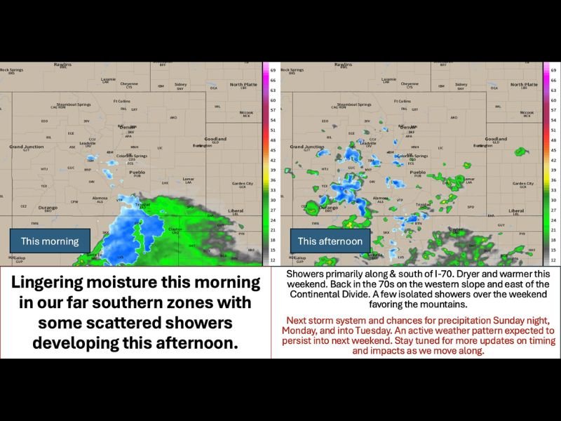
Morning Moisture Clears South While Afternoon Showers Fire Along and South of I-70
Daytime heating on Friday will push popcorn-style showers to develop across the central and southern mountains and along the southern I-25 corridor into the southeast plains during the afternoon and evening hours. The bulk of shower activity will remain focused along and south of I-70, keeping most of the Denver metro and northern Front Range relatively quiet through the day.
Winds will not be a significant factor on Friday, with variable speeds averaging 5 to 15 mph driven by diurnal heating patterns. Barometric pressure is expected to remain fairly steady throughout the day, keeping conditions manageable across most of the region.
Drier and Warmer Weekend Brings Temperatures Back Into the 70s Statewide
Conditions will improve noticeably heading into Saturday and Sunday, with drier air and warming temperatures returning across Colorado. The western slope and areas east of the Continental Divide are expected to climb back into the 70s, with the far eastern plains potentially touching the low 80s on the warmest days of the weekend stretch.
A few isolated showers will still be possible over the weekend, mainly favoring the mountains, but widespread rain is not expected. Residents across the Front Range and plains should enjoy the brief dry and warm window before the next round of active weather arrives.
Next Storm System Targets Colorado Sunday Night Through Tuesday With Active Pattern Continuing
Forecast models are signaling the arrival of another storm system and cold front as early as Sunday night, with precipitation impacts expected to carry through Monday and into Tuesday. The active weather pattern is then forecast to persist into next week and beyond, keeping Colorado in a stormy and unsettled weather regime through at least mid-month.
Residents should begin monitoring the Sunday night through Tuesday window closely as timing and impact details come into better focus over the coming days. Precautions should be kept in mind starting late Saturday or early Sunday ahead of the next system. Stay with NapervilleLocal.com for the latest weather updates and local forecast coverage.

I’ve lived in Naperville long enough to see how quickly our community changes — from new developments downtown to sudden shifts in our Midwest weather. Reporting on Naperville news and daily forecasts gives me the chance to keep neighbors informed about what really matters. My goal is simple: deliver clear, timely updates so you always know what’s happening in our city and what to expect from the skies above.