
Cold Front, Mountain Snow, Gusts Over 50mph and Rain Targeting Colorado Including Denver, Cheyenne, and Colorado Springs Monday Night Into Tuesday With Much Colder Air Behind
COLORADO — A significant cold front is set to blow through Colorado beginning Monday afternoon and continuing through Tuesday, bringing a dramatic shift from warm and breezy Sunday conditions to rain, mountain snow, and much colder temperatures. The front sweeps through Cheyenne Monday afternoon, Denver Monday evening, and southern Colorado Monday night, with north winds gusting 35 to 45 mph behind the front. Snow levels will drop to 6000 feet by midnight Monday and as low as 5500 feet by Tuesday morning as a trough of low pressure approaches from the west.
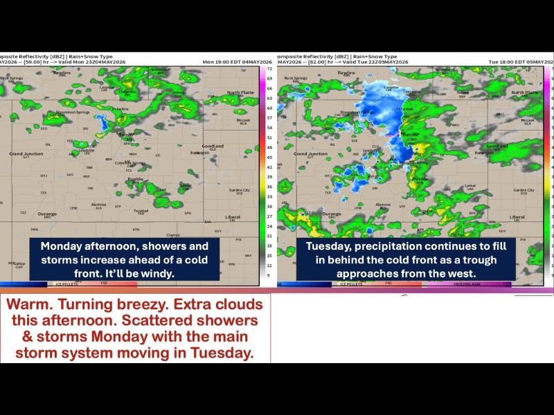
Warm and Breezy Sunday Turns Stormy Monday Ahead of Cold Front Passage
Sunday will feel warm with temperatures in the 70s and low 80s including the Western Slope, but winds will already be in the 15 to 25 mph range ahead of the approaching cold front. Widely scattered showers and a couple of thunderstorms are possible along Cheyenne Ridge on Sunday afternoon, though most of the region will stay dry.
Monday brings increasing storms and showers ahead of the cold front, with winds strengthening significantly through the day. Winds ahead of the front will gust to 35 mph broadly, with mountain wave development on the Divide pushing gusts over 50 mph across the foothills and higher terrain.
Cold Front Sweeps Through Denver Monday Evening Dropping Snow Levels to 5500 Feet
The cold front pushes through Cheyenne Monday afternoon, reaches Denver Monday evening, and completes its passage through southern Colorado Monday night. Behind the front, north winds will run 15 to 25 mph with gusts of 35 to 45 mph and wind direction shifting out of the north and northeast.
Snow levels drop rapidly behind the front, falling to 6000 feet by midnight Monday and continuing down to 5500 feet by Tuesday morning. High mountain snow will accompany Monday night’s storms as colder air floods the region.
Tuesday Brings Widespread Precipitation as Western Trough and Cold Front Phase Together
Tuesday’s forecast hinges on how the cold front and approaching western trough phase together, with precipitation continuing to fill in across Denver, Colorado Springs, Pueblo, and the Front Range through the day. Rain, snow, and much colder temperatures define Tuesday and potentially linger into Wednesday before a drying and warming trend develops beyond midweek. Stay with NapervilleLocal.com for the latest weather updates and local forecast coverage.

I’ve lived in Naperville long enough to see how quickly our community changes — from new developments downtown to sudden shifts in our Midwest weather. Reporting on Naperville news and daily forecasts gives me the chance to keep neighbors informed about what really matters. My goal is simple: deliver clear, timely updates so you always know what’s happening in our city and what to expect from the skies above.