
Rain and Strong Storms Surging North Across the Eastern US Wednesday Night Into Thursday With Heaviest Activity Targeting the South in an Active Spring Pattern
EASTERN US — The next round of rain and storms is on the way for the eastern United States, arriving late Wednesday into Thursday as an active spring pattern continues delivering moisture across the region. European model data is showing a significant and broad rain surge pushing northward across the eastern half of the country during the Wednesday PM through Thursday window, with the heaviest and most intense activity concentrated across the southern tier. Strong storms are possible mainly to the south, while early Thursday timing may help limit storm fuel across northern portions of the coverage zone.
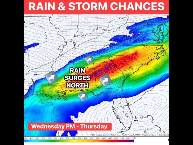
Heavy Rain Surging North Across Broad Eastern Corridor Wednesday Night Into Thursday
The European model is painting a vivid and expansive rain shield moving northward across the eastern US, with the most intense red and orange returns concentrated from the Gulf Coast states through the Carolinas and mid-Atlantic region. The rain surge arrows on forecast modeling confirm a clear northward push of moisture, pulling the heaviest activity from south to north through the overnight Wednesday into Thursday morning timeframe.
The breadth of this system means widespread rain coverage across multiple states simultaneously, with rainfall totals varying significantly depending on proximity to the core of the moisture surge and the track of the associated low pressure center near the Gulf Coast.
Strong Storms Possible Mainly to the South While Thursday Timing May Limit Northern Fuel
The strongest storm potential with this system is focused mainly across southern portions of the coverage area, where the highest moisture and instability values will be in place ahead of the approaching system. The early Thursday timing of the system’s arrival across northern zones may work to limit available storm fuel, potentially keeping the severe threat more confined to southern regions.
Forecasters are monitoring the system closely given the tendency for spring setups to shift track late, which could alter the rainfall distribution significantly between now and Wednesday.
Active Spring Pattern Delivering Continued Rain Chances After Uneven Recent Stretch
The region has entered a more reliably active weather pattern after a stretch of scattered and uneven rain distribution that left some areas well watered and others notably dry. Wednesday night into Thursday represents the next opportunity for meaningful and widespread rainfall across the eastern US, with additional chances expected to follow as the active spring pattern persists through the coming week. Stay with NapervilleLocal.com for the latest weather updates and local forecast coverage.

I’ve lived in Naperville long enough to see how quickly our community changes — from new developments downtown to sudden shifts in our Midwest weather. Reporting on Naperville news and daily forecasts gives me the chance to keep neighbors informed about what really matters. My goal is simple: deliver clear, timely updates so you always know what’s happening in our city and what to expect from the skies above.