
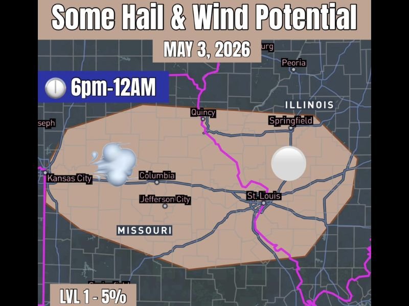
Small Hail and Gusty Winds Possible Across Eastern Missouri and Western Illinois Including St. Louis, Springfield and Kansas City Sunday Evening 6PM Through Midnight
MISSOURI AND ILLINOIS — A low end severe weather chance is in play across eastern Missouri and western Illinois on Sunday evening, May 3, 2026, as a weak atmospheric wave kicks off some elevated storm development through the 6 PM to midnight window. The threat is not a major setup by any measure, but a Level 1 five percent hail and wind potential exists across the outlined zone covering Kansas City, Columbia, Jefferson City, St. Louis, Quincy, and Springfield Illinois. Small pocket change hail and gusty winds are the primary hazards to monitor through the Sunday evening hours.
Low End Hail and Wind Threat Covers Eastern Missouri and Western Illinois This Evening
The Level 1 five percent risk zone covers a broad swath of eastern Missouri and western Illinois, with the risk area stretching from near Kansas City in the west through Columbia, Jefferson City, and St. Louis before extending into Quincy and Springfield Illinois on the eastern side. A weak wave moving through the region is providing just enough lift and instability to support some elevated storm development during the evening hours.
While the overall threat remains low end and non-major, storms that do develop within this zone carry the potential to produce small hail and gusty winds capable of creating brief and localized hazardous conditions for residents caught outdoors during the evening hours.
Pocket Change Hail and Gusty Winds the Main Hazards From 6PM Through Midnight
The primary hazard window runs from 6 PM through midnight on Sunday, covering the peak evening hours when storm activity is most likely to develop and move through the risk zone. Hail, if it occurs, is expected to remain on the smaller end of the scale, and wind gusts would be brief rather than sustained and widespread.
This is not a setup that warrants significant concern, but residents across the St. Louis metro, Kansas City, and the western Illinois communities of Quincy and Springfield should remain casually aware of storm development during the Sunday evening timeframe.
Overall Setup Remains Minor With No Major Severe Weather Concerns Sunday
The overall character of Sunday’s severe setup is minor and brief, with confidence remaining low that widespread or impactful severe weather will materialize across the risk zone. Residents across eastern Missouri and western Illinois should enjoy their Sunday while keeping a passive eye on evening storm development between 6 PM and midnight. Stay with NapervilleLocal.com for the latest weather updates and local forecast coverage.

I’ve lived in Naperville long enough to see how quickly our community changes — from new developments downtown to sudden shifts in our Midwest weather. Reporting on Naperville news and daily forecasts gives me the chance to keep neighbors informed about what really matters. My goal is simple: deliver clear, timely updates so you always know what’s happening in our city and what to expect from the skies above.