
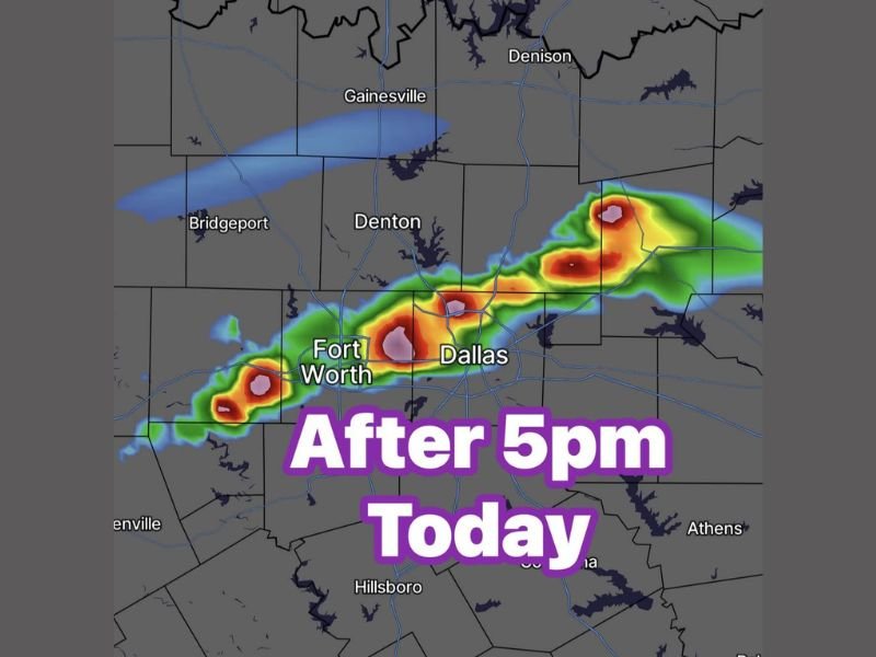
Large Hail, Damaging Winds and Heavy Rain Targeting Dallas Fort Worth Metroplex Including Denton and Gainesville After 5PM Today as Cold Front Moves In Tonight
DALLAS FORT WORTH — Scattered strong to severe storms are being watched for development across the Dallas Fort Worth metroplex after 5 PM today, Tuesday May 5, 2026, with a conditional risk remaining in place if the atmospheric cap breaks during the late afternoon heating hours. Radar simulation is showing intense red and pink cores developing directly over Fort Worth and Dallas through the early evening hours. A cold front moving in tonight will be the primary trigger, with overall 30 percent storm coverage expected across the metroplex before conditions clear.
Cap Breaking After 5PM Could Trigger Large Hail and Damaging Winds Across the Metroplex
The entire severe weather scenario hinges on whether the cap is able to break during the late afternoon hours across the DFW area. If storms fire successfully, they will be capable of producing large hail, damaging winds, and dangerous lightning through the early evening hours.
Temperatures are expected to reach the low 90s ahead of the cold front, providing significant heat and instability fuel if storms are able to punch through the cap after 5 PM.
Fort Worth and Dallas Sitting Under Heaviest Simulated Storm Cores This Evening
Radar simulation data shows the most intense storm cores positioned directly over Fort Worth and Dallas during the after 5 PM window, with additional storm activity extending northeast toward Denton and Gainesville. The pink and red simulated returns indicate the potential for very heavy rainfall rates and significant storm intensity within these cores.
Pockets of heavy rain capable of causing brief localized street flooding accompany the hail and wind threat across the most intense storm corridors through the early evening.
30 Percent Coverage Expected Across the Metroplex Before Cold Front Clears Tonight
Overall storm coverage across the DFW metroplex is forecast at around 30 percent, meaning not every community will see severe weather but the threat is widespread enough to warrant awareness across the entire area. The cold front clears the region tonight, ending storm chances and bringing cooler and drier conditions behind the system. Stay with NapervilleLocal.com for the latest weather updates and local forecast coverage.

I’ve lived in Naperville long enough to see how quickly our community changes — from new developments downtown to sudden shifts in our Midwest weather. Reporting on Naperville news and daily forecasts gives me the chance to keep neighbors informed about what really matters. My goal is simple: deliver clear, timely updates so you always know what’s happening in our city and what to expect from the skies above.