
Strong Tornado, Very Large Hail and Damaging Winds Targeting Louisiana and Mississippi Including Jackson, Shreveport and Monroe Wednesday as Cold Front Drives Discrete Supercells
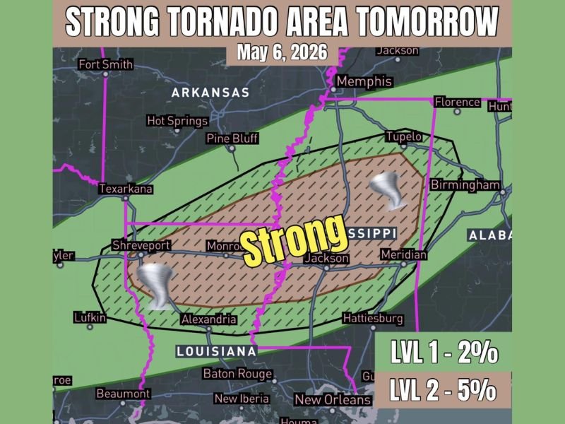
LOUISIANA AND MISSISSIPPI — A strong tornado area is in place for Wednesday, May 6, 2026, across Louisiana and Mississippi as a cold front continues sliding south through the region, driving discrete supercell development capable of all severe weather modes. The highest risk hatched zone covers a broad corridor from Shreveport and Monroe through Jackson, Meridian, Tupelo, and surrounding communities, with a Level 2 five percent tornado probability at the core and a Level 1 two percent zone extending outward. Wind shear and instability strongly favor discrete supercells initially, capable of producing very large hail and a strong tornado before linear storm modes take over.
Strong Tornado Possible Across Louisiana and Mississippi as Supercells Fire Wednesday
The hatched brown tornado zone covers the highest confidence area for strong tornado development, stretching from near Shreveport and Alexandria in Louisiana through Jackson, Monroe, Meridian, and Tupelo in Mississippi. Discrete supercells firing along the cold front will be capable of all severe weather modes at least initially.
The environment strongly supports tornado development across this corridor, with wind shear and instability values favorable for sustained supercell organization during the Wednesday threat window.
Very Large Hail and Damaging Winds Accompany the Tornado Threat Wednesday
Beyond the tornado risk, very large hail and damaging winds are expected with the stronger supercell storms developing across Louisiana and Mississippi on Wednesday. The multi-mode threat profile makes this a particularly dangerous severe weather setup across the outlined risk zone.
As storms mature through the day, linear storm modes will eventually take over, shifting the primary threat toward damaging winds across the broader green marginal zone covering Memphis, Hot Springs, Pine Bluff, Birmingham, and Hattiesburg.
Broader Marginal Zone Extends From Arkansas Through Alabama and Tennessee
The wider green risk zone pulls in communities from Fort Smith and Hot Springs through Tupelo, Florence, and Birmingham into the broader severe weather picture for Wednesday. Residents across Louisiana and Mississippi inside the hatched core zone should treat Wednesday as a serious tornado threat day requiring advance shelter preparation and active weather alerts. Stay with NapervilleLocal.com for the latest weather updates and local forecast coverage.

I’ve lived in Naperville long enough to see how quickly our community changes — from new developments downtown to sudden shifts in our Midwest weather. Reporting on Naperville news and daily forecasts gives me the chance to keep neighbors informed about what really matters. My goal is simple: deliver clear, timely updates so you always know what’s happening in our city and what to expect from the skies above.