
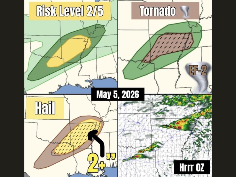
Very Large Hail 2 Inches Plus, EF-2 Tornado and Damaging Winds Targeting Northern Arkansas Through Memphis Under Level 2 Risk Tuesday May 5 With Supercells Moving Southeast
ARKANSAS AND MEMPHIS — Very large hail is the primary severe weather mode today, Tuesday May 5, 2026, with at least a couple of supercells expected to form across northern Arkansas and quickly move southeast toward the Memphis area. The outlook places a Level 2 of 5 Slight Risk across the Arkansas corridor, with a hatched tornado zone indicating EF-2 tornado potential across the same region. Hail exceeding 2 inches is the highest confidence threat, with a strong tornado remaining possible if storms successfully tap into the warm sector ahead of the cold front.
Very Large 2 Inch Plus Hail the Primary Threat Across Northern Arkansas Today
The hail threat zone sits across northern Arkansas as a hatched yellow and brown oval, with 2 inch plus hail carrying the highest probability of any hazard in today’s setup. At least a couple of discrete supercells are expected to develop across northern Arkansas and track southeast through the afternoon.
These supercells will be capable of producing very large and damaging hail with each storm core that develops and maintains organization through the warm sector environment.
EF-2 Tornado Possible if Supercells Successfully Tap the Warm Sector
The tornado probability zone covers northern Arkansas with a hatched brown area indicating EF-2 tornado potential. Whether storms can tap the warm sector or remain behind their own outflow boundary is the critical question determining tornado risk today.
If supercells successfully access the warm sector with sufficient speed shear and instability in place, a strong tornado reaching EF-2 intensity cannot be ruled out across the northern Arkansas into western Tennessee corridor.
Texas Faces Weaker Setup With Large Hail and Brief Tornado Still Possible
Further south into Texas, the low level jet is considerably weaker, making sustained storm organization more difficult through the afternoon. However, very large hail and a brief tornado remain possible if any storm manages to establish itself and maintain organization long enough across the northeast Texas corridor. Stay with NapervilleLocal.com for the latest weather updates and local forecast coverage.

I’ve lived in Naperville long enough to see how quickly our community changes — from new developments downtown to sudden shifts in our Midwest weather. Reporting on Naperville news and daily forecasts gives me the chance to keep neighbors informed about what really matters. My goal is simple: deliver clear, timely updates so you always know what’s happening in our city and what to expect from the skies above.