
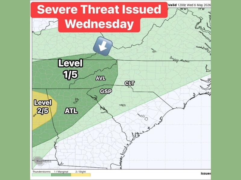
Damaging Storms and 1 Inch Plus Rain Targeting Atlanta, Asheville, Greenville and Charlotte Wednesday Night After Midnight Under Level 2 and Level 1 Severe Risk With Weekend Rain Chances Lingering
SOUTHEAST — A severe weather risk has been officially issued for Wednesday, May 6, 2026, across the Southeast, with storms looking more intense during the afternoon and evening hours before the main event arrives after midnight. A Level 2 of 5 Slight Risk is in place near Atlanta and the western portions of the region, while a Level 1 Marginal Risk covers Asheville, Greenville, and Charlotte extending across the broader Carolinas zone. Most areas should pick up around 1 inch of rain with some higher totals possible.
Level 2 Slight Risk Covers Atlanta With Storms Feisty Through Afternoon and Evening
The highest severe weather confidence sits near Atlanta and the western edge of the risk zone under the Level 2 yellow designation. Storms are expected to be more feisty through the Wednesday afternoon and evening hours across this zone before the main event pushes through after midnight.
Forecasters are watching storms tracking back toward Tennessee and Alabama through the afternoon to gauge how well organized they remain heading into the evening hours.
Level 1 Marginal Risk Covers Asheville, Greenville and Charlotte Through Wednesday
The Level 1 Marginal Risk zone extends across western North Carolina and Upstate South Carolina, covering Asheville, Greenville, and Charlotte through Wednesday. Rain with thunder and lightning is expected through the afternoon and evening across this zone.
The main and most impactful round of weather arrives after midnight for most of the region, making Wednesday night into early Thursday morning the period demanding the most attention and preparedness.
Around 1 Inch of Rain Expected With Front Possibly Stalling Into the Weekend
Most areas across the risk zone will pick up around 1 inch of rain with some localized higher totals through the event. There are also signs the front may stall nearby, bringing off-and-on rain chances lingering into the weekend.
Mother’s Day weekend does not currently look like a complete washout, but additional updates will be needed as the stalling front situation becomes clearer through the week. Stay with NapervilleLocal.com for the latest weather updates and local forecast coverage.

I’ve lived in Naperville long enough to see how quickly our community changes — from new developments downtown to sudden shifts in our Midwest weather. Reporting on Naperville news and daily forecasts gives me the chance to keep neighbors informed about what really matters. My goal is simple: deliver clear, timely updates so you always know what’s happening in our city and what to expect from the skies above.