
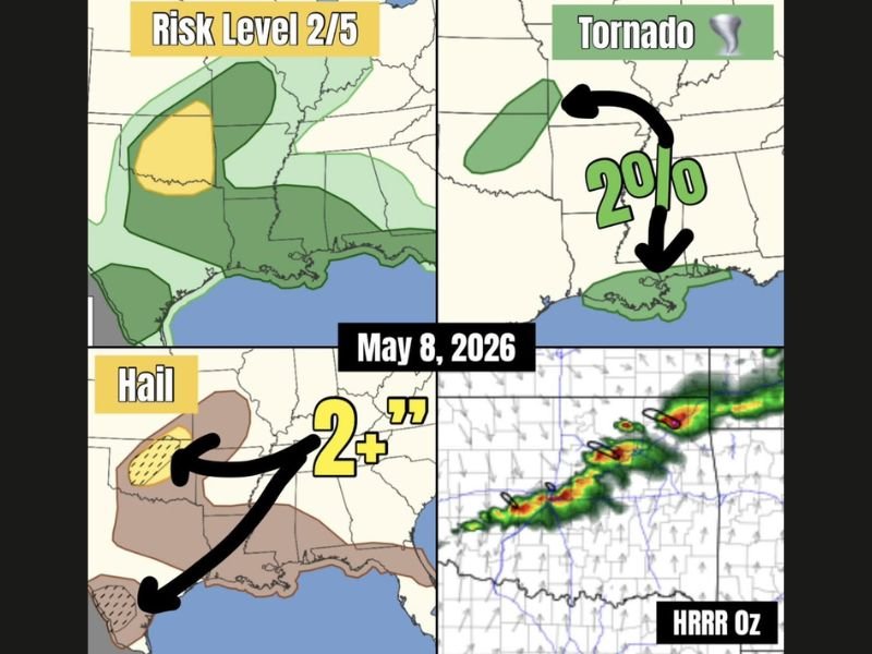
Tennis Ball Size Hail and Damaging Winds Risk Across Central Oklahoma Including Oklahoma City and Surrounding Areas With Isolated Tornado Chance as Storms Move Southeast
OKLAHOMA — Severe weather risk returns to central Oklahoma today as northwest flow helps trigger high-based thunderstorms and transient supercells during the afternoon. The setup carries a Risk Level 2 out of 5, with hail expected to be the main concern. Some storms could produce hail up to tennis ball size, along with damaging winds and a low tornado risk if storm bases lower.
High-Based Storms Develop Across Central Oklahoma
Northwest flow across central Oklahoma is expected to help kick off a wave of thunderstorms this afternoon. Some storms may briefly take on supercell characteristics as they organize and move southeast.
The strongest activity is not expected everywhere, but any storm that strengthens could become capable of producing hazardous conditions. The highlighted risk area places the main concern over central Oklahoma and nearby surrounding areas.
Hail Risk Stands Out as the Main Threat
The most notable hazard in this setup is hail, with some stones potentially reaching tennis ball size. The graphic highlights a 2-inch-plus hail signal, showing that stronger storms could become efficient hail producers.
This makes hail damage a concern for vehicles, roofs, windows, and outdoor equipment. Anyone in the risk area should consider sheltering cars and securing exposed items before storms arrive.
Damaging Winds and Tornado Chance Remain Possible
Damaging winds are also possible with stronger storms, especially if cells become more organized. High-based storms can produce strong outflow winds even when rainfall coverage is limited.
The tornado risk is shown at 2 percent, meaning the overall threat is low but not zero. A tornado would be more possible if storm bases lower enough during the afternoon setup.
Storms Expected to Move Southeast
Storm motion is expected to be toward the southeast, which means areas downstream of central Oklahoma should watch conditions closely. The HRRR model panel shows a broken line of storms developing and tracking across the region.
The main message is not a widespread outbreak, but a focused severe weather threat with large hail potential. Residents should monitor warnings through the afternoon and be ready to move indoors quickly if storms approach. Stay with NapervilleLocal.com for the latest weather updates and local forecast coverage.

I’ve lived in Naperville long enough to see how quickly our community changes — from new developments downtown to sudden shifts in our Midwest weather. Reporting on Naperville news and daily forecasts gives me the chance to keep neighbors informed about what really matters. My goal is simple: deliver clear, timely updates so you always know what’s happening in our city and what to expect from the skies above.