
Omega Block Pattern Locking In Above Normal Heat Across the Central and Eastern US With Ring of Fire Thunderstorm Risk Possible Along Ridge Boundaries May 15 Through May 22
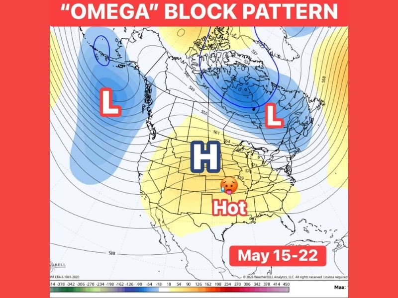
NATIONAL — An Omega Block weather pattern is developing for the second half of May, potentially locking above normal temperatures across the central and eastern United States from May 15 through May 22, 2026. This powerful blocking pattern occurs when areas of high and low pressure become locked in place rather than moving west to east as they normally do, with the jet stream resembling a horseshoe or the Greek letter Omega on weather maps. The result is a stuck and prolonged pattern that could deliver an extended stretch of above normal heat across a broad portion of the country.
Omega Block Locks Warm Air in Place Across Central and Eastern US Through Late May
The high pressure dome shown centered across the central United States will act as the anchor of the Omega Block pattern, keeping warmer than normal air locked in place across the central and eastern portions of the country through the May 15 to 22 window. Low pressure systems on both the western and eastern flanks of the high are trapped and unable to move through, creating the classic blocked pattern.
Weather patterns caught inside an Omega Block tend to remain stuck for several days, meaning above normal temperatures could persist for an extended stretch rather than a brief one or two day warming event.
Ring of Fire Thunderstorm Chances Possible Along the Ridge Boundaries
A notable secondary concern with this Omega Block setup is the potential for what forecasters call a Ring of Fire pattern, where repeated thunderstorm chances ride along the boundaries of the dominant ridge. Communities situated along these boundary zones could see recurring and organized storm chances through the May 15 to 22 period while areas locked inside the ridge experience the hottest and driest conditions.
The strength and exact position of the ridge boundaries will determine how active and impactful the Ring of Fire storm potential becomes through the second half of May.
Pattern Being Watched Closely as Strength and Duration Remain Uncertain
How strong and long lasting this Omega Block becomes is still being monitored closely through forecast models heading into mid-May. A robust and well-defined block could deliver one of the more significant heat stretches of the spring season across the central and eastern US through late May. Stay with NapervilleLocal.com for the latest weather updates and local forecast coverage.

I’ve lived in Naperville long enough to see how quickly our community changes — from new developments downtown to sudden shifts in our Midwest weather. Reporting on Naperville news and daily forecasts gives me the chance to keep neighbors informed about what really matters. My goal is simple: deliver clear, timely updates so you always know what’s happening in our city and what to expect from the skies above.