
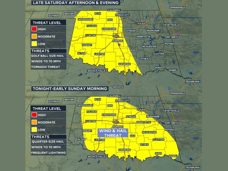
Golf Ball Hail, 70mph Winds and Tornado Threat Firing Across Western Oklahoma Including OKC, Lawton and Norman Late Saturday Afternoon Into Evening With More Storms Redeveloping Overnight
OKLAHOMA — Severe storms will refire across western Oklahoma late Saturday afternoon, May 9, 2026, bringing a tornado, wind, and hail threat as storms develop and push eastward through the evening hours. The storm zone covers a broad yellow risk area stretching from Woodward, Alva, and Enid through Oklahoma City, Norman, Lawton, and Ardmore southward to Wichita Falls. Golf ball sized hail, winds up to 70 mph, and a tornado threat are all confirmed hazards for the late Saturday afternoon and evening window, with more storms expected to redevelop overnight.
Golf Ball Hail and 70mph Winds Targeting OKC Through Lawton and Norman Saturday Evening
The primary storm zone covers western and central Oklahoma with the most significant threats being golf ball sized hail and wind gusts reaching up to 70 mph. Oklahoma City, Norman, Kingfisher, Clinton, Hobart, Altus, and Lawton all sit inside the active yellow risk zone for Saturday afternoon and evening storm development.
Storms firing across west Oklahoma will develop and move eastward through the evening hours, bringing the full hazard package through the risk zone through the overnight period.
Tornado Threat Active Across the Saturday Afternoon and Evening Storm Zone
A tornado threat accompanies the hail and wind hazards across the western and central Oklahoma storm zone through Saturday evening. Residents across Oklahoma City, Norman, Ardmore, and Wichita Falls should have weather alerts active and shelter plans ready before storms arrive during the late afternoon hours.
The tornado threat will be most active during the discrete storm phase early in the event before storm organization evolves through the evening and overnight hours.
Wind and Hail Threat Continues Into Sunday Morning Across Central Oklahoma
A second storm zone map covering Sunday morning shows the wind and hail threat continuing across the same central Oklahoma corridor including OKC, Norman, Lawton, and surrounding communities through the overnight into early Sunday window. Temperatures Saturday are running in the upper 80s to low 90s across western Oklahoma, providing significant heat and instability fuel for storm development through the afternoon uncapping window.
Stay with NapervilleLocal.com for the latest weather updates and local forecast coverage.

I’ve lived in Naperville long enough to see how quickly our community changes — from new developments downtown to sudden shifts in our Midwest weather. Reporting on Naperville news and daily forecasts gives me the chance to keep neighbors informed about what really matters. My goal is simple: deliver clear, timely updates so you always know what’s happening in our city and what to expect from the skies above.