
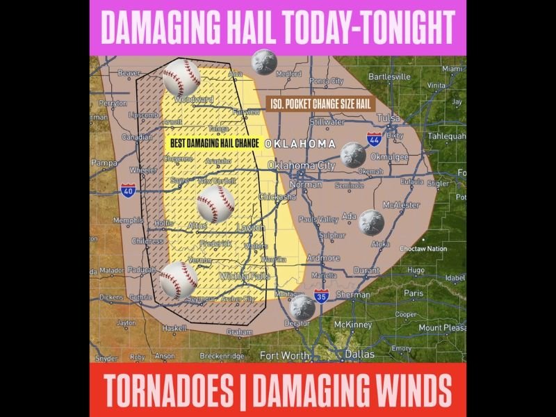
Baseball Sized Hail, Tornadoes and Damaging Winds Targeting Oklahoma and North Texas Including Lawton, Wichita Falls and Oklahoma City Saturday Afternoon Through Sunday Morning
OKLAHOMA AND NORTH TEXAS — A couple to a few rounds of severe storms are possible across Oklahoma and parts of north Texas from this afternoon through Sunday morning, May 9 to 10, 2026. The strongest storms early on could produce baseball sized hail across the best damaging hail zone covering western Oklahoma from Woodward through Sayre, Lawton, and Wichita Falls.
Tornadoes and damaging winds are also possible across the broader risk zone through the overnight hours into Sunday morning. Hail will be isolated in nature meaning neighboring communities can experience dramatically different outcomes just miles apart.
Baseball Sized Hail Possible Across Western Oklahoma and North Texas This Afternoon
The best damaging hail zone is outlined across western Oklahoma and the north Texas border region, covering Woodward, Cheyenne, Arapaho, New Cordell, Altus, Lawton, Frederick, Wichita Falls, and Vernon. Baseball sized hail is the maximum threat across this hatched yellow inner core during the early afternoon storm development window.
The strongest storms firing early in the event carry the highest hail size potential before hail sizes decrease later tonight into Sunday morning as storm organization evolves.
Hail Isolated in Nature Means Neighboring Towns Could See Dramatically Different Results
A critical detail about today’s hail threat is its highly isolated and spotty nature across the risk zone. One community could be pelted with baseball sized hail while a neighboring town just a few miles away sees no rain whatsoever from the same storm cluster.
This unpredictable and isolated distribution makes weather alerts absolutely essential for all residents across the risk zone, as there will be little advance visual warning before a hail-producing storm arrives.
Tornadoes and Damaging Winds Possible Through Overnight Hours Into Sunday Morning
Beyond the hail threat, a couple of tornadoes and damaging winds are possible across Oklahoma and north Texas through the overnight hours and into Sunday morning. The broader tan risk zone extends from western Oklahoma eastward through Oklahoma City, Tulsa, and the surrounding communities through the multi-round event window.
All residents across Oklahoma and north Texas should have weather alerts active and be prepared to move indoors immediately when storm warnings are issued through Saturday night. Stay with NapervilleLocal.com for the latest weather updates and local forecast coverage.

I’ve lived in Naperville long enough to see how quickly our community changes — from new developments downtown to sudden shifts in our Midwest weather. Reporting on Naperville news and daily forecasts gives me the chance to keep neighbors informed about what really matters. My goal is simple: deliver clear, timely updates so you always know what’s happening in our city and what to expect from the skies above.