
Tornadoes Large Hail and Damaging Winds Targeting Plains States Including Oklahoma Kansas Texas and Missouri With Multiple Rounds of Severe Weather Friday Through Sunday May 16 and 17
PLAINS STATES — A significant severe weather pattern is set to ramp up across the Plains this weekend as warm, humid air surges northward, bringing multiple rounds of dangerous storms to Oklahoma, Kansas, Texas, and Missouri from Friday through Sunday.
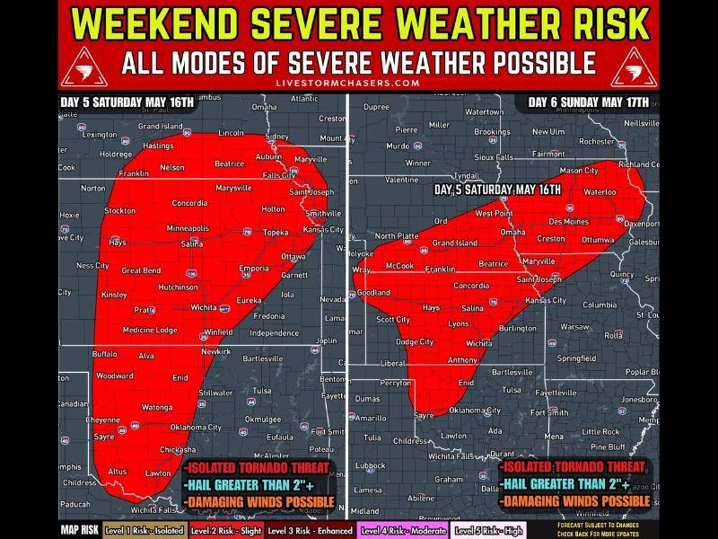
All modes of severe weather are possible across the outlined risk zones, including isolated tornadoes, hail greater than two inches in diameter, and damaging winds. Sunday carries the highest overall threat level, with the western Oklahoma through central and eastern Kansas corridor emerging as the greatest area of concern for the most significant severe weather.
Friday Kicks Off the Weekend Severe Weather Threat Across North Texas Oklahoma Eastern Kansas and Missouri
The severe weather pattern gets its start on Friday as storms begin developing across North Texas, Oklahoma, eastern Kansas, and Missouri during the afternoon and evening hours. A few storms within this initial round could reach severe criteria by late afternoon, bringing the first taste of what shapes up to be a very active severe weather weekend across the Plains.
Friday’s setup is the least organized of the three-day stretch, but it serves as the opening act for a pattern that intensifies considerably heading into Saturday and Sunday. Residents across all four states should treat Friday afternoon as the beginning of an extended period of weather awareness rather than an isolated event.
Saturday Brings Supercell Threat With Large Hail Over 2 Inches and Tornadoes Possible Across Kansas and Oklahoma
Saturday, May 16 represents a major severe weather day across the Plains, with storms expected to fire near a dryline stretching from western Oklahoma northward into Kansas. The risk zone on Saturday covers an enormous swath of territory from southern Oklahoma and the Lawton area northward through Oklahoma City, Enid, Wichita, Hutchinson, Salina, Topeka, and Kansas City, extending into Nebraska.
Some storms on Saturday are expected to become supercells capable of producing significant severe weather, including hail exceeding two inches in diameter, damaging winds, and isolated tornadoes. The threat is categorized as an isolated tornado threat with high-end hail and wind potential, making Saturday the day that demands the most preparation across the central and southern Plains.
Sunday May 17 Sees Threat Increase Further With Western Oklahoma Through Central Kansas as Greatest Concern
Sunday, May 17 could match or exceed Saturday’s threat level as richer moisture pushes further northward across the southern and central Plains. The greatest concern on Sunday runs from western Oklahoma through central and eastern Kansas, with storm development expected during the afternoon and evening bringing tornado potential, large hail, and severe winds back to the region.
A larger storm complex may also develop Sunday night and push toward the Mid-Missouri Valley, extending the severe weather threat into the overnight hours. Residents across Oklahoma, Kansas, Texas, and Missouri should plan for multiple weather awareness check-ins throughout the entire weekend and have shelter plans confirmed well before Friday afternoon arrives. Stay with NapervilleLocal.com for the latest weather updates and local forecast coverage.

I’ve lived in Naperville long enough to see how quickly our community changes — from new developments downtown to sudden shifts in our Midwest weather. Reporting on Naperville news and daily forecasts gives me the chance to keep neighbors informed about what really matters. My goal is simple: deliver clear, timely updates so you always know what’s happening in our city and what to expect from the skies above.