
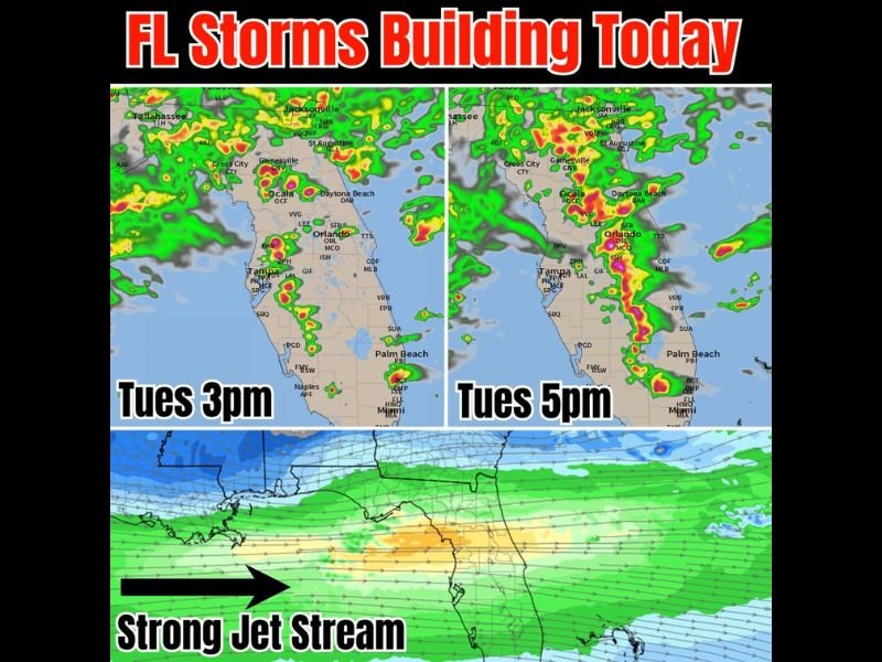
Storms Building Across Florida Including Jacksonville Tampa Orlando and Palm Beach With Strong Gulf Jet Stream Fueling Increasing Activity From 3PM Through 5PM Tuesday
FLORIDA — A strong jet stream pushing inland from the Gulf is driving storm development across Florida today, Tuesday, with activity expected to increase significantly during the afternoon hours. Storms are beginning to fire along the west coast during the early afternoon before spreading inland across the middle of the state and pushing eastward through the late afternoon and early evening. Model guidance shows storm coverage expanding notably between 3:00 PM and 5:00 PM, with the most intense cells concentrated across Central Florida and along the east coast corridor by mid-afternoon.
Storms Begin Along West Coast Early Afternoon Before Spreading Inland Toward Orlando and Central Florida
The initial round of storm development is focused along Florida’s west coast during the early afternoon hours, with Tampa and surrounding areas among the first to see activity fire up today. As the afternoon progresses, storms are expected to pop inland across the middle of the state with Central Florida including Orlando becoming increasingly active heading into the 3:00 PM timeframe.
The strong jet stream incoming from the Gulf is providing the upper-level support needed to help storms develop and sustain themselves longer than they might on a typical afternoon. That added energy from above is a key reason why storm coverage is expected to be more widespread than usual today across the Florida peninsula.
Storm Coverage Expands Significantly Between 3PM and 5PM From Jacksonville Through Miami Corridor
Model radar projections show a notable increase in storm intensity and coverage between 3:00 PM and 5:00 PM across a broad swath of Florida. By the 3:00 PM frame, storms are scattered from the Jacksonville and St. Augustine area southward through Gainesville, Ocala, Orlando, and Tampa with additional cells firing near Naples and the southwest coast.
By 5:00 PM the coverage becomes more organized and intense, with heavier storm cells pushing eastward toward Daytona Beach, the Palm Beach area, and down toward Miami. The east coast of Florida sees a particularly active push of storms during the late afternoon window, making this the highest impact period of the day for communities along that corridor.
Classic El Nino Jet Stream Pattern Could Mean More Active Storm Days Through Fall and Winter
Beyond today’s storm threat, the strong jet stream setup being observed carries longer range implications for Florida’s weather pattern. The current atmospheric configuration resembles a classic El Nino pattern, which forecasters note could result in more frequent and more energized storm days across the region toward the end of the year through fall and winter.
Most areas are expected to see conditions quiet down heading into the weekend as today’s active pattern shifts through. Residents across Florida should treat Tuesday afternoon as the peak of the current active stretch and plan accordingly, with the 3:00 PM to 5:00 PM window carrying the highest storm potential statewide. Stay with NapervilleLocal.com for the latest weather updates and local forecast coverage.

I’ve lived in Naperville long enough to see how quickly our community changes — from new developments downtown to sudden shifts in our Midwest weather. Reporting on Naperville news and daily forecasts gives me the chance to keep neighbors informed about what really matters. My goal is simple: deliver clear, timely updates so you always know what’s happening in our city and what to expect from the skies above.