
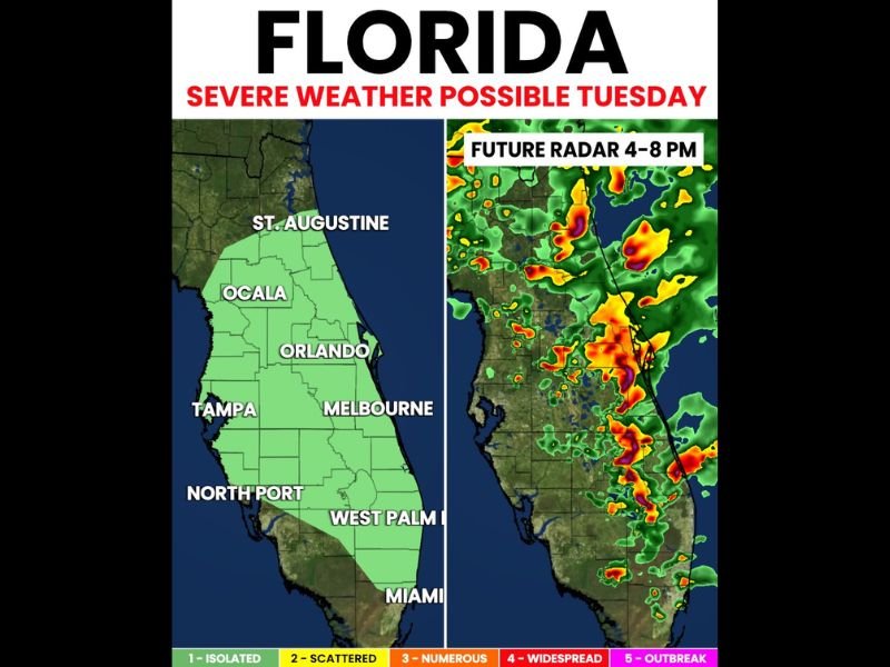
Severe Storms and Spin-Up Tornado Threat Across Florida Including Orlando Tampa Melbourne and West Palm Beach This Tuesday Afternoon Into Evening
FLORIDA — Scattered strong to severe storms are possible across Florida this Tuesday afternoon and evening, with the highest threat concentrated across the eastern half of the peninsula from St. Augustine southward through Orlando, Melbourne, West Palm Beach, and Miami. Storms capable of producing frequent lightning, larger hail, gusty winds, and even a brief spin-up tornado cannot be ruled out during the primary window running from 4:00 PM through 8:00 PM. Greater rainfall totals and storm coverage are expected along the east coast, though Tampa, North Port, and Ocala still carry storm chances through the evening.
Primary Threat Zone Covers Eastern Florida From St. Augustine Through Orlando and Miami
The green-shaded risk zone places Florida’s east coast squarely in the highest threat corridor for this afternoon and evening. Communities from St. Augustine down through Ocala, Orlando, Melbourne, West Palm Beach, and Miami all sit within the area where strong to severe storm development is most likely between 4:00 PM and 8:00 PM.
Future radar projections show intense storm activity pushing across this corridor during the peak threat period. The heaviest cells are forecast to track along the east coast spine of the state, bringing the full range of severe weather hazards to densely populated communities throughout the evening hours.
Frequent Lightning Large Hail Gusty Winds and Brief Spin-Up Tornado All Possible
Any storm reaching severe criteria today could produce frequent lightning, larger hail, and gusty winds across the outlined zone. A brief spin-up tornado also cannot be ruled out, as the atmospheric setup supports enough low-level shear for a quick rotation event if the right storm develops over the right location this afternoon.
West Coast Including Tampa and North Port Still Carries Storm Chances This Evening
While east coast coverage will be significantly heavier, west coast communities including Tampa, North Port, and Ocala are not completely out of the picture and should remain weather-aware through the evening. Anyone across the Florida peninsula with outdoor plans this Tuesday should have alerts active before 3:00 PM and be ready to move indoors quickly if warnings are issued. Stay with NapervilleLocal.com for the latest weather updates and local forecast coverage.

I’ve lived in Naperville long enough to see how quickly our community changes — from new developments downtown to sudden shifts in our Midwest weather. Reporting on Naperville news and daily forecasts gives me the chance to keep neighbors informed about what really matters. My goal is simple: deliver clear, timely updates so you always know what’s happening in our city and what to expect from the skies above.