
Multiple Tornadoes Very Large Hail and Damaging Winds Targeting Texas Through Wisconsin Including Oklahoma City Kansas City Chicago and Minneapolis Monday May 18
CENTRAL PLAINS — A large and potentially significant severe weather event is taking shape for Monday, May 18, 2026, with very large hail, damaging winds, and multiple tornadoes all likely across a massive corridor stretching from Texas northward through Oklahoma, Kansas, Missouri, Iowa, and into Wisconsin. The threat carries genuine outbreak potential and covers an enormous geographic footprint across the central United States. Residents across all affected states should begin preparations now and spread awareness of this growing threat well before Monday arrives.
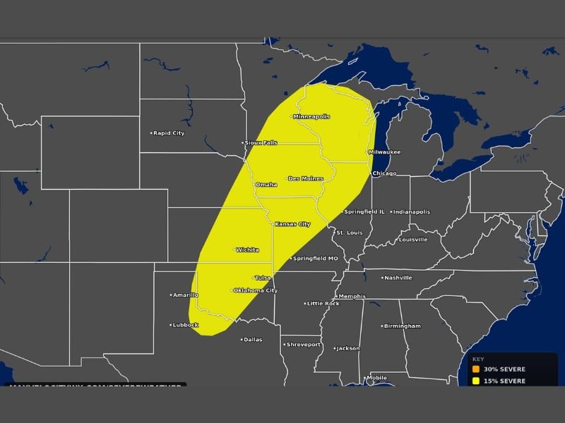
The outlined yellow risk zone spans from near Dallas and Oklahoma City southward through Wichita, Kansas City, Omaha, Des Moines, Sioux Falls, Minneapolis, Milwaukee, and Chicago. This large-scale multi-state setup signals that this situation deserves immediate and serious attention across the entire corridor.
All Modes of Severe Weather Likely Across Full Risk Zone From Texas Through Wisconsin
All modes of severe weather are on the table for Monday, with very large hail, damaging winds, and multiple tornadoes each carrying a likely rather than merely possible designation. That language reflects elevated forecaster confidence that these hazards will materialize across portions of the risk area rather than remaining isolated or marginal threats.
The 15 percent severe weather probability zone covers the full yellow-shaded corridor from Texas through Wisconsin. Any supercell that develops within this environment will need to be taken extremely seriously by anyone in its path.
Outbreak Potential Centered From Oklahoma City and Wichita Through Kansas City and Omaha
The combination of hazards, geographic scale, and forecaster language points to genuine severe weather outbreak potential across the central portion of the risk zone. The Oklahoma City through Wichita, Kansas City, and Omaha corridor represents the heart of the threat where storm coverage and intensity are expected to peak on Monday afternoon and evening.
Residents across this corridor have several days to prepare and should use that time to confirm shelter locations and ensure weather alerts are active. Checking updated forecasts daily through the weekend is strongly advised as confidence in specific details increases heading into Monday. Stay with NapervilleLocal.com for the latest weather updates and local forecast coverage.

I’ve lived in Naperville long enough to see how quickly our community changes — from new developments downtown to sudden shifts in our Midwest weather. Reporting on Naperville news and daily forecasts gives me the chance to keep neighbors informed about what really matters. My goal is simple: deliver clear, timely updates so you always know what’s happening in our city and what to expect from the skies above.