
Scattered Storms Gusty Winds and Lightning Targeting Colorado Including Denver Colorado Springs Fort Collins and Pueblo With Upper 80s and Low 90s This Wednesday Afternoon
COLORADO — A hot and unsettled Wednesday is taking shape across Colorado and surrounding areas on May 13, 2026, with widespread upper 80s and low 90s building across the region while scattered afternoon showers and storms develop during the afternoon and evening hours. Gusty winds between 35 and 55 mph and frequent lightning are the primary risks with any storm that fires today. An elevated wildfire risk is also in play given the hot temperatures, gusty winds, and low dew points across the region.
Moisture creeping in from the southwest at mid and high levels is fueling the scattered storm development, but with low dew point temperatures at the surface, much of the rainfall is expected to evaporate before reaching the ground. That evaporating precipitation will drive dangerous downburst winds outward at the surface, making gusty winds the bigger and more widespread story compared to actual rainfall totals today.
Gusty Winds 35 to 55mph and Lightning Are Primary Risks With Afternoon Storms Across Front Range
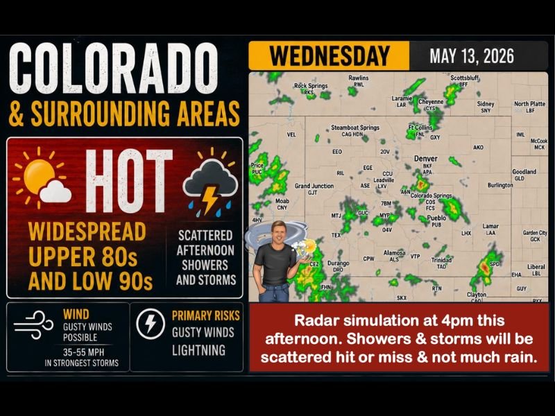
Any shower or storm developing this afternoon across Colorado carries the potential for gusty winds reaching 35 to 55 mph in the strongest cells, along with dangerous lightning. The radar simulation shows storm activity scattered across the Denver metro, Colorado Springs, Pueblo, and Fort Collins corridor during the 4:00 PM timeframe, with additional cells firing across southern Colorado near Durango and Alamosa.
Storms today will be hit or miss in nature, meaning some areas see nothing while neighboring communities get hit with strong gusty winds and lightning. Air travel disruptions are likely during the afternoon storm window, and early morning flights remain the safest option for anyone moving through Colorado airports today.
Wildfire Risk Elevated Statewide With Heat Gusty Winds and Dry Conditions Combining
Beyond the storm threat, wildfire conditions are elevated across Colorado today as hot temperatures, gusty winds, and dry air combine to create a dangerous fire weather environment. Even with scattered storm activity, the overall dryness of the atmosphere means little to no effective rainfall will reach the ground across most areas.
Storm and wildfire awareness should remain high through Thursday as similar conditions persist, with the gusty shower and storm threat continuing east of the Continental Divide along the Front Range, I-25 corridor, and eastern plains. Stay with NapervilleLocal.com for the latest weather updates and local forecast coverage.

I’ve lived in Naperville long enough to see how quickly our community changes — from new developments downtown to sudden shifts in our Midwest weather. Reporting on Naperville news and daily forecasts gives me the chance to keep neighbors informed about what really matters. My goal is simple: deliver clear, timely updates so you always know what’s happening in our city and what to expect from the skies above.