
Very Large Hail and Damaging Winds Targeting Central Plains Including Wichita Kansas City Omaha and Tulsa With Supercell Threat Thursday May 14
CENTRAL PLAINS — Significant severe weather is possible across the Central Plains on Thursday, May 14, 2026, with a few supercells expected to become capable of producing very large hail and intense damaging winds during the afternoon and evening hours.
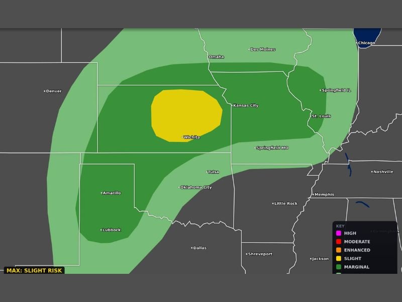
The categorical outlook shows a Slight Risk core centered over the Wichita corridor extending toward Kansas City, with a broader Marginal Risk zone fanning outward through Omaha, Des Moines, Tulsa, Oklahoma City, and into portions of Illinois and Missouri. Residents across the entire outlined zone should prepare now and protect vehicles ahead of Thursday’s storm threat.
Supercells Capable of Very Large Hail and Intense Winds Especially Near I-40 Corridor in Kansas
The I-40 corridor through Kansas sits in the heart of the highest risk zone on Thursday, where supercell development during the afternoon and evening hours carries the most significant severe weather potential of the day. Very large hail is the primary concern with these storms, and the size and intensity of hail events with supercells in this environment could be significant enough to cause serious damage to vehicles, roofs, and other exposed property.
Intense damaging winds are the secondary threat alongside the hail, with any supercell that develops in the Slight Risk zone capable of producing both hazards either simultaneously or in rapid succession. Anyone in the Wichita through Kansas City corridor should have vehicles sheltered and outdoor plans adjusted before Thursday afternoon arrives.
Marginal Risk Extends Through Omaha Des Moines Tulsa and Springfield Missouri
Surrounding the Slight Risk core, a broad Marginal Risk zone covers a large portion of the Central Plains including Omaha, Des Moines, Tulsa, Oklahoma City, Springfield Missouri, and St. Louis. Communities across this wider zone carry a lower but still real threat for severe weather Thursday afternoon and evening.
Residents from the Texas Panhandle northward through Kansas, Missouri, and into Iowa should stay weather aware throughout the day and have alerts active well before the afternoon storm window opens on Thursday. Stay with NapervilleLocal.com for the latest weather updates and local forecast coverage.

I’ve lived in Naperville long enough to see how quickly our community changes — from new developments downtown to sudden shifts in our Midwest weather. Reporting on Naperville news and daily forecasts gives me the chance to keep neighbors informed about what really matters. My goal is simple: deliver clear, timely updates so you always know what’s happening in our city and what to expect from the skies above.