
Very Large Hail Over 2 Inches and Supercell Threat Targeting Central Kansas With Weak Tornado Possible Thursday May 14
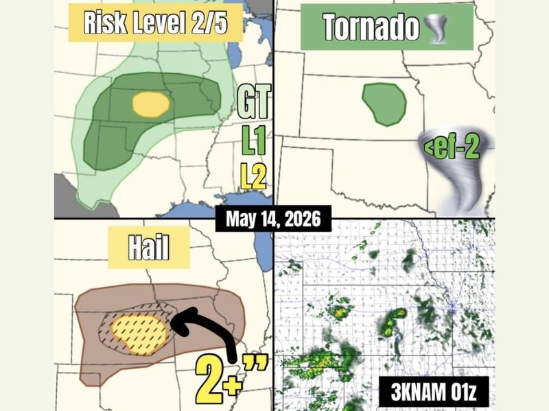
CENTRAL KANSAS — Central Kansas is the primary area to watch today, May 14, 2026, as a shortwave passes over a dryline while a warm front sits to the east, providing the potential lift needed to initiate storms. A Risk Level 2 out of 5 is in place across the outlined zone, with very large hail exceeding 2 inches the main threat if storms manage to develop. The cap is strong and overall forcing is weak, keeping storm development confidence low, but any supercell that does fire could become significant.
Short-term high-resolution model guidance is not strongly supporting storm development today, but the ingredients for dangerous storms exist if that cap breaks during peak afternoon heating hours.
Elevated Supercells Capable of Very Large Hail Over 2 Inches If Storms Develop
Should storms manage to overcome the strong cap today across central Kansas, they would likely take the form of elevated or high-based supercells capable of producing very large hail exceeding 2 inches in diameter. The hail threat zone is concentrated across the central Kansas corridor where the dryline and shortwave interaction is most favorable for any storm initiation.
The 2-plus inch hail potential is significant enough to cause serious vehicle and property damage for any community that falls directly under a developing supercell this afternoon.
Tornado Potential Remains Very Low But Cannot Be Ruled Out With Supercell Mode Possible
Tornado potential today across central Kansas is rated as very low, carrying only a 2 percent probability on the outlook. That number reflects the weak overall setup and strong cap suppressing storm development, but tornado risk is never truly zero when supercell storm modes are possible in any environment.
Any tornado that develops today would be expected to remain below EF-2 intensity and short-lived in duration given the overall limitations of the atmospheric setup across the region.
Strong Cap and Weak Forcing Keep Overall Storm Confidence Low Across the Region
The biggest factor working against significant storm development today is the combination of a strong atmospheric cap and weak overall forcing across central Kansas. These limiting factors are keeping short-term model guidance from aggressively supporting storm initiation through the afternoon hours.
Residents across central Kansas should remain weather aware through the afternoon and evening regardless of the low confidence, as a cap break in the right location could still produce a dangerous and fast-developing supercell with little advance warning. Stay with NapervilleLocal.com for the latest weather updates and local forecast coverage.

I’ve lived in Naperville long enough to see how quickly our community changes — from new developments downtown to sudden shifts in our Midwest weather. Reporting on Naperville news and daily forecasts gives me the chance to keep neighbors informed about what really matters. My goal is simple: deliver clear, timely updates so you always know what’s happening in our city and what to expect from the skies above.