
Heat Continues Into the 80s and 90s Across Colorado and Front Range With Scattered Storms and Pattern Change Arriving This Weekend Into Monday
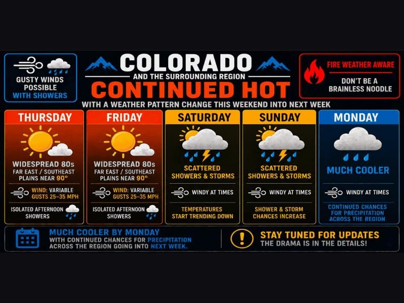
COLORADO — Continued hot conditions are in place across Colorado and the surrounding region Thursday and Friday, with widespread 80s statewide and far east and southeast plains touching near 90 degrees both days. Isolated gusty afternoon showers are possible Thursday and Friday with variable winds gusting 25 to 35 mph, but most areas will see no measurable precipitation. A significant pattern change arrives this weekend with scattered storms, increasing winds, and much cooler temperatures expected by Monday.
Fire weather awareness remains in effect given the hot temperatures, gusty winds, and dry conditions continuing through Friday across the region.
Thursday and Friday Stay Hot With Isolated Gusty Showers and 25 to 35mph Wind Gusts
Both Thursday and Friday feature widespread 80s across Colorado with the far east and southeast plains climbing near 90 degrees. Variable winds gusting between 25 and 35 mph will accompany any isolated afternoon shower that develops, producing gusty outflow and blinding dust in some areas.
Most of the region will not see any measurable rainfall through Friday, with only isolated and hit-or-miss shower activity expected during peak afternoon heating hours.
Weekend Brings Scattered Storms and Cooling Temperatures Ahead of Monday Pattern Change
Saturday and Sunday both feature scattered showers and thunderstorms across the region as temperatures begin trending downward from the hot Thursday and Friday readings. Weekend temperatures remain in the 70s and 80s for most areas, with far east and southeast plains still touching the low 90s before the bigger cooldown arrives.
Storm chances increase further Sunday with windy conditions persisting through both weekend days as the approaching storm system draws closer to the region.
Much Cooler Temperatures and Widespread Precipitation Chances Arrive Monday
Monday brings a dramatic pattern shift across Colorado and surrounding areas, with temperatures potentially struggling to climb out of the 50s across portions of the region. Good chances for showers and precipitation are expected statewide as the storm system moves through, with GFS and Euro models both supporting an active weather pattern continuing deeper into next week.
Residents should begin preparing for the weekend wind increase and the sharp Monday cooldown well in advance, especially those with outdoor plans across the Front Range and eastern plains. Stay with NapervilleLocal.com for the latest weather updates and local forecast coverage.

I’ve lived in Naperville long enough to see how quickly our community changes — from new developments downtown to sudden shifts in our Midwest weather. Reporting on Naperville news and daily forecasts gives me the chance to keep neighbors informed about what really matters. My goal is simple: deliver clear, timely updates so you always know what’s happening in our city and what to expect from the skies above.