
TORCON 7 Violent Tornado Outbreak Baseball Size Hail and 75mph Winds Targeting Nebraska Iowa and Minnesota Including Sioux City Omaha Sioux Falls and Grand Island Today
NEBRASKA — Two days of violent and life-threatening severe weather are unfolding across the central Plains and upper Midwest, with TORCON 7 values centered over Sioux City, Omaha, and Norfolk today representing an extreme tornado threat. Supercells firing this afternoon and evening will produce baseball size hail, intense EF3-plus tornadoes, and hurricane-force winds from embedded bow echoes as the cold front pushes east. Monday brings a rapid atmospheric recovery with another round of violent tornadoes possible from Northern Michigan to North Texas with TORCON 7 again centered near Nebraska City through Wichita.
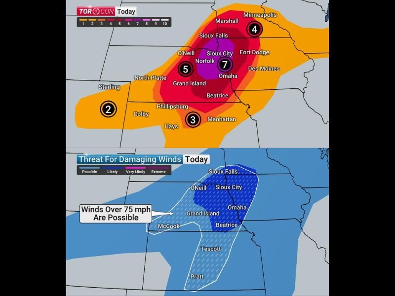
TORCON 7 Centered Over Sioux City Omaha and Norfolk With EF3 Plus Tornadoes and Baseball Hail Today
The TORCON 7 purple core centered over Sioux City, Norfolk, and Omaha represents a 70 percent tornado probability within 50 miles — an extraordinarily dangerous designation. Some tornadoes today could be intense EF3-plus and long-lived, tracking through the Sioux Falls, Sioux City, and Norfolk corridor through the afternoon and evening hours.
Park vehicles under cover, remove loose outdoor items, and consider sleeping on a lower level tonight if large trees surround your home.
Winds Over 75mph Possible Across Grand Island Sioux City and Omaha Corridor Tonight
As the cold front pushes east tonight, a squall line with embedded bow echoes will produce hurricane-force wind gusts exceeding 75 mph across the Grand Island, Sioux City, Beatrice, and Omaha corridor. This extreme wind threat develops during overnight hours when most residents will be asleep, making advance preparation absolutely critical before darkness falls.
The damaging wind threat zone covers a significant area from McCook northward through Sioux Falls with extreme conditions possible across the dark blue highest probability corridor.
Monday Brings Second Round of Violent Tornadoes From Northern Michigan Through North Texas
Monday sees the atmosphere recover rapidly and produce another violent tornado event, with TORCON 7 values again centered near Nebraska City through Wichita. Baseball size hail or greater, intense EF3-plus tornadoes, and extreme widespread winds are all expected again Monday before conditions push eastward overnight.
Tuesday sees the tornado risk subside substantially, though strong wind-producing storms continue across the Great Lakes and Mid-South through the day. Stay with NapervilleLocal.com for the latest weather updates and local forecast coverage.

I’ve lived in Naperville long enough to see how quickly our community changes — from new developments downtown to sudden shifts in our Midwest weather. Reporting on Naperville news and daily forecasts gives me the chance to keep neighbors informed about what really matters. My goal is simple: deliver clear, timely updates so you always know what’s happening in our city and what to expect from the skies above.