
Strong to Severe Storms With Damaging Winds and Hail Sweeping Across Arkansas Including Fort Smith Fayetteville Little Rock and Jonesboro This Tuesday Morning
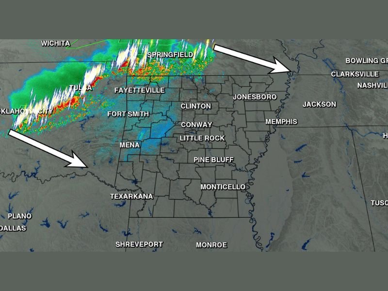
ARKANSAS — Storms are arriving across Arkansas Tuesday morning exactly as forecasted, with the entire state expected to see rain and thunderstorm activity as the system pushes through during the day. Radar at 6:04 AM shows an intense line of storms tracking from Oklahoma and Missouri southeastward directly into Arkansas, with the heaviest activity currently focused across the Fort Smith and Fayetteville corridor. Some storms could reach strong to severe criteria with damaging winds and hail as the primary concerns while tornado risk remains very low.
Intense Storm Line Tracking Southeast From Oklahoma Into Fort Smith and Fayetteville
The 6:04 AM radar presentation shows a well-organized and intense line of storms moving southeast from the Oklahoma and Missouri border region directly into northwest Arkansas. The Fort Smith, Fayetteville, and Mena corridor are among the first Arkansas communities feeling the effects of the incoming storm line this morning.
The line contains lightning-intense cells with the strongest reflectivity values concentrated along the leading edge of the storm complex tracking toward central Arkansas.
Entire State Expects Rain and Storms Through Tuesday With Damaging Winds and Hail Possible
The storm system will impact the entire state of Arkansas through Tuesday as it continues tracking southeast. Damaging winds and hail are the main severe weather concerns with any stronger cells that develop, while the tornado risk is described as very low with this primarily linear storm setup.
Communities including Little Rock, Conway, Jonesboro, Pine Bluff, Monticello, and Texarkana should all expect storm activity to arrive through the morning and afternoon hours.
Residents Across Arkansas Should Stay Weather Aware Through Tuesday
With storms sweeping statewide through Tuesday, all Arkansas residents should keep weather alerts active and monitor conditions throughout the day. While today is not a major tornado outbreak scenario, damaging winds and hail from stronger cells can develop quickly within linear storm systems.
Have shelter plans ready and avoid unnecessary travel during the heaviest storm activity as the line pushes through your area. Stay with NapervilleLocal.com for the latest weather updates and local forecast coverage.

I’ve lived in Naperville long enough to see how quickly our community changes — from new developments downtown to sudden shifts in our Midwest weather. Reporting on Naperville news and daily forecasts gives me the chance to keep neighbors informed about what really matters. My goal is simple: deliver clear, timely updates so you always know what’s happening in our city and what to expect from the skies above.